Pooler, GA
| Pooler, Georgia | |
|---|---|
| City | |

|
|
| Motto: Pride, Family, Honor | |
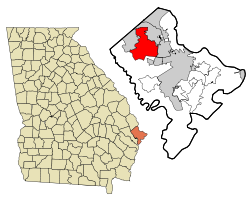
 Location in Chatham County and the state of Georgia |
|
| Coordinates: 32°6′17″N 81°15′12″W / 32.10472°N 81.25333°WCoordinates: 32°6′17″N 81°15′12″W / 32.10472°N 81.25333°W | |
| Country | United States |
| State | Georgia |
| County | Chatham |
| Government | |
| • Mayor | Mike Lamb |
| Area | |
| • Total | 30.3 sq mi (78.6 km2) |
| • Land | 29.4 sq mi (76.1 km2) |
| • Water | 1.0 sq mi (2.5 km2) |
| Elevation | 20 ft (6 m) |
| Population (2010) | |
| • Total | 19,140 |
| • Estimate (2016) | 23,744 |
| • Density | 721/sq mi (278.4/km2) |
| Time zone | Eastern (EST) (UTC-5) |
| • Summer (DST) | EDT (UTC-4) |
| ZIP code | 31322 |
| Area code(s) | 912 |
| FIPS code | 13-62104 |
| GNIS feature ID | 0332725 |
| Website | pooler-ga |
Pooler is a city in Chatham County, Georgia, United States. According to 2010 US Census, the population was 19,140, a threefold increase over the 2000 count of 6,239. The 2013 population estimate was 21,187. Pooler is located northwest of Savannah along I-95 and Interstate 16.
The city was named for railroad employee Robert William Pooler.
During the Civil War, Pooler was a railway stop called Pooler's Station—the last stop before Savannah on the Central of Georgia Railway. In December 1864, Pooler was a meeting place for Union officers led by William Tecumseh Sherman, who negotiated with Savannah authorities for the strategic port city's peaceful surrender.
Today, Pooler is the center for commercial development in west Chatham County. Godley Station, the center for business development, has been successful in attracting large companies such as construction equipment manufacturer JCB to the area. Newer shopping centers such as The Shops at Godley Station are bringing new revenue to the area. Low crime and a small-town community atmosphere have all been factors in its explosive growth. Pooler is now one of Georgia's fastest-growing cities.
Pooler is located in northwestern Chatham County at 32°6′17″N 81°15′12″W / 32.10472°N 81.25333°W. It is bordered by Port Wentworth to the north, Garden City to the east, a far-flung portion of Savannah to the southwest, and Bloomingdale to the northwest. U.S. Route 80 intersects Interstate 95 just east of the city center; US 80 leads 9 miles (14 km) east to downtown Savannah, while I-95 leads north into South Carolina and south 132 miles (212 km) to Jacksonville, Florida.
...
Wikipedia
