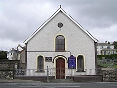
Pomeroy, County Tyrone
| Pomeroy | |
|---|---|
 Pomeroy Presbyterian Church |
|
| Pomeroy shown within Northern Ireland | |
| Population | 604 (2001 Census) |
| District | |
| County | |
| Country | Northern Ireland |
| Sovereign state | United Kingdom |
| Post town | Dungannon |
| Postcode district | BT70 |
| Dialling code | 028 |
| EU Parliament | Northern Ireland |
| UK Parliament | |
| NI Assembly | |
Pomeroy is a small village and civil parish in County Tyrone, Northern Ireland. It is in the townland of Cavanakeeran, about 8.5 miles (14 km) from Cookstown, 9 miles (14 km) from Dungannon and 16 miles (26 km) from Omagh. The 2001 Census recorded a population of 604 people.
Pomeroy is atop a large hill that dominates the surrounding countryside. From the Cookstown end, the road through the village gradually climbs a gradient up to a village square, The Diamond. The village is surrounded by the Pomeroy Hills. The surrounding countryside is a mixture of moorland and bog land. Stone age and Bronze Age cairns dot the landscape. Pomeroy is the closest settlement to the geographical centre of Ulster.
At the end of the 17th century there was no village in this area, just an extensive forest. In the plantation of Ulster James I and VI granted eight townlands to Sir William Parsons, Surveyor General of Ireland. In 1729 James Lowry inherited the land from his father, Robert of Aghenis Caledon.
In the 18th century two new parishes were created in Tyrone, and the same family, the Lowrys (from whom issued the Earls of Belmore), was involved in the establishment of both. Pomeroy was created from part of Donaghmore, while Clogherny was taken from Termonmaguirc. The arrangement was confirmed in 1731 by an Order in Council, which had the same legal status as an Act of Parliament, and the articles of agreement under which it was conducted by the two parties involved, Lord Tyrone and Robert Lowry, suggest the tone:
...
Wikipedia

