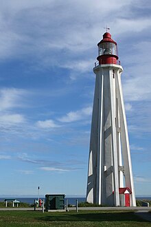
Pointe-au-Père lighthouse

Pointe-au-Père Lighthouse
|
|
|
Quebec
|
|
| Location |
Rimouski, Quebec Canada |
|---|---|
| Coordinates | 48°31′03″N 68°28′07″W / 48.51750°N 68.46861°WCoordinates: 48°31′03″N 68°28′07″W / 48.51750°N 68.46861°W |
| Year first constructed | 1859 (first) |
| Year first lit | 1909 (current) |
| Deactivated | 1975 |
| Construction | concrete tower |
| Tower shape | sixteen-sided cylinder with eight buttresses tower |
| Markings / pattern | white tower, red lantern and balcony |
| Height | 108 feet (33 m) |
| Original lens | Third order Fresnel |
| Admiralty number | H2084 |
| NGA number | 6768 |
| ARLHS number | CAN-394 |
| Official name | Pointe-au-Père Lighthouse National Historic Site of Canada |
| Designated | 1974 |
The 3rd Pointe-Au-Père lighthouse was built in 1909 in the city of Pointe-au-Père, near Rimouski, Quebec, Canada. This city was well known in naval circles as the location of the pilot station for the Bas-Saint-Laurent (lower St. Lawrence) zone. Pointe-au-Père has since been amalgamated into the larger city of Rimouski (2002).
The lighthouse is 108 feet tall, which makes it the second tallest in eastern Canada. It is built in a characteristic shape, employing eight concrete buttresses to support a slender central cylinder.
It was replaced by an electronic lighthouse in 1975 and the site is now open for visitors as part of the Site historique maritime de la Pointe-au-Père. The RMS Empress of Ireland shipwrecking is documented in the Empress of Ireland Pavilion and you can also visit the only submarine open to the public in Canada, HMCS Onondaga (S73).
The site was designated a National Historic Site of Canada in 1974.
...
Wikipedia

