Poesten Kill
| Poesten Kill | |
| River | |
|
Poesten Kill adjacent to New York Route 2 in Brunswick
|
|
| Country | United States |
|---|---|
| State | New York |
| Region | Rensselaer County |
| Part of | Hudson River Watershed |
| Tributaries | |
| - left | Newfoundland Creek |
| - right | Bonesteel Creek, Quacken Kill, Sweet Milk Creek |
| Source | Dyken Pond |
| - location | Berlin, New York, United States |
| - elevation | 1,624 ft (495 m) |
| - coordinates | 42°43′2.74″N 73°25′40.58″W / 42.7174278°N 73.4279389°W |
| Mouth | Hudson River |
| - location | Troy, New York, United States |
| - elevation | 0 ft (0 m) |
| - coordinates | 42°43′14.49″N 73°41′54″W / 42.7206917°N 73.69833°WCoordinates: 42°43′14.49″N 73°41′54″W / 42.7206917°N 73.69833°W |
| Length | 26.2 mi (42 km) |
| Basin | 89.4 sq mi (232 km2) |
| Discharge | |
| - average | 130 cu ft/s (4 m3/s) |
| - max | 2,897 cu ft/s (82 m3/s) |
|
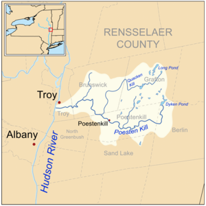
Watershed of the Poesten Kill and its tributaries
|
|
The Poesten Kill is a 26.2-mile-long (42.2 km)creek in upstate New York located entirely in Rensselaer County, which flows westerly from its source at Dyken Pond in the town of Berlin to its mouth at the Hudson River in the city of Troy. It has been used historically as a source of water for local inhabitants and farmers and became even more important as a source of water power during the Industrial Revolution, during which many mills and factories sprung up along its banks.
Its name is derived from the name of a local farmer that lived near the creek in the 1660s, and the Dutch word kill, meaning creek.
The Poesten Kill begins at Dyken Pond, a man-made body of water located in the Petersburg Mountains, about 20 miles (32 km) east of the Hudson River. It was created by the Manning Paper Company in 1902 in an effort to control stream flow and prevent flooding. Dyken Pond is fed by local streams and springs and is located near the corners of the towns of Grafton, Berlin, and Poestenkill at an elevation of 1,624 feet (495 m).
While many small streams discharge into the Poesten Kill, there are only four notable tributaries of the creek. Bonesteel Creek runs southerly from Bonesteel and Hosjord Ponds and connects with the Poesten Kill in the town of Poestenkill between the hamlets of Barberville and Ives Corner. Bonesteel Creek is about 5.4 miles (8.7 km) long. Newfoundland Creek is the next tributary and joins the Poesten Kill just west of the hamlet of Poestenkill. It is about 3.6 miles (5.8 km) long. The Quacken Kill is the next tributary and connects in the town of Poestenkill near the Brunswick border. The Quacken Kill begins at Long Pond at Grafton Lakes State Park and continues through Second Pond and Mill Pond, also in the park, before continuing through Dunham Reservoir near central Grafton. It is about 15.9 miles (25.6 km) long. The next major tributary is Sweet Milk Creek, which begins as a stream in north central Brunswick and travels about 4.7 miles (7.6 km) before combining in the southwestern portion of the town.
...
Wikipedia


