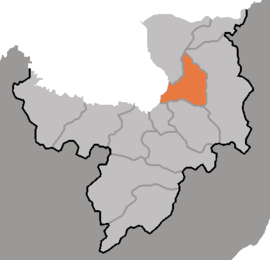
Pochon County
|
Poch'ŏn County 보천군 |
|
|---|---|
| County | |
| Korean transcription(s) | |
| • Chosŏn'gŭl | |
| • Hancha | |
| • McCune–Reischauer | Poch'ŏn-gun |
| • Revised Romanization | Bocheon-gun |
 |
|
| Country | North Korea |
| Province | Ryanggang |
| Administrative divisions | 1 ŭp, 2 workers' districts, 17 ri |
Poch'ŏn County is a kun, or county, in Ryanggang Province, North Korea. It looks westward across the Amrok River at China.
The Masingryong Mountains pass through the county, which slopes downward gradually to the west. The county sits atop the Paektu Plateau, with the mountains rising to only a small relative height. The highest peak is Namp'ot'aesan (남포태산). There are numerous streams, of which the chief is the Karimch'ŏn. Some 83% of the county's area is taken up by forestland. The temperatures are quite cold.
The predominant local industry is logging. There are also deposits of magnetite, alunite, and obsidian. Poch'ŏn's farms produce potatoes, wheat and barley, among other crops; orchards and livestock farms are also found.
Poch'ŏn is served by the Samjiyŏn and Poch'ŏn (Paektusan Rimch'ŏl) lines of the Korean State Railway, and also by roads.
Pochon-gun is divided into 1 up (town), 2 rodongjagu (workers' districts) and 17 ri (villages):
...
Wikipedia
