Požega, Croatia
| Požega | |||||
|---|---|---|---|---|---|
| City | |||||
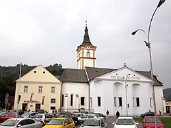
Top: Church of the Holy Ghost; Bottom left: Bishop's Palace; Bottom right: Orljava river;
|
|||||
|
|||||
| Location of Požega in Croatia | |||||
| Coordinates: 45°19′59″N 17°40′25″E / 45.33306°N 17.67361°ECoordinates: 45°19′59″N 17°40′25″E / 45.33306°N 17.67361°E | |||||
| Country |
|
||||
| County |
|
||||
| Founded | 12th century | ||||
| Government | |||||
| • Mayor | Vedran Neferović (HDZ) | ||||
| Area | |||||
| • City | 133.91 km2 (51.70 sq mi) | ||||
| Elevation | 311 m (1,020 ft) | ||||
| Population (2011) | |||||
| • City | 26,248 | ||||
| • Density | 200/km2 (510/sq mi) | ||||
| • Urban | 19,506 | ||||
| Time zone | CET (UTC+1) | ||||
| • Summer (DST) | CEST (UTC+2) | ||||
| Postal code | 34000 | ||||
| Area code | +385 34 | ||||
| Vehicle registration | PŽ | ||||
| Website | http://www.pozega.hr/ | ||||
Požega (pronounced [pôʒeɡa]) is a city in western Slavonia, eastern Croatia, with a total population of 26,248 (census 2011). It is the administrative center of the Požega-Slavonia County.
Between 1921 and 1991, the town was known as Slavonska Požega. In German, the town is known as Poschegg, in Hungarian as Pozsega, in Turkish as Pojega, and in Latin as Incerum (-i, n.) and Possega. There is a town in Serbia with same name (see: Požega, Serbia).
Požega (elevation: 152 m (499 ft)) is located in the south-western part of the Valley of Požega, or Požega basin, in Croatian: Požeška kotlina. This fertile valley has been important since the antiquity - its Roman name was Vallis Aurea, meaning "golden valley".
The valley is formed by the Slavonian mountains of Požeška Gora, Psunj, Papuk, Krndija and Dilj.
Two state roads run concurrently through the city: the D38 Pakrac — Požega — Pleternica — Đakovo and the D51 Nova Gradiška — Požega — Našice, as well as a railroad: Nova Kapela/Batrina — Pleternica — Požega — Velika.
...
Wikipedia


