Plum Island, New York
| Native name: mannituve | |
|---|---|
 |
|
|
Plum Island (New York)
|
|
| Geography | |
| Location | Atlantic Ocean |
| Coordinates | 41°10′59″N 72°11′25″W / 41.18306°N 72.19028°WCoordinates: 41°10′59″N 72°11′25″W / 41.18306°N 72.19028°W |
| Total islands | 1 |
| Area | 840 acres (340 ha) |
| Length | 3 mi (5 km) |
| Width | 1 mi (2 km) |
| Administration | |
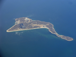
Plum Island is an island in the Town of Southold in Suffolk County, New York in the United States. The island is situated in Gardiners Bay, east of Orient Point, off the eastern end of the North Fork coast of Long Island. It is about 3 miles (4.8 km) long and 1-mile (1.6 km) wide at its widest point.
The island is the site of the Plum Island Animal Disease Center (PIADC) which was established by the United States Department of Agriculture (USDA) in 1954. The Island is also the site of the former U.S. military installation Fort Terry (c. 1897), and the historic Plum Island Light (c. 1869), and its automated replacement.
Plum Island is owned in its entirety by the United States government, which was considering sale of the island as part of a debt-reduction package. but suspended the plan in February 2012. Access to the island is controlled by the United States Department of Homeland Security (DHS).
On August 29, 2013, the United States General Services Administration (GSA) and United States Department of Homeland Security (DHS) announced a final "Record of Decision (ROD): Public Sale of Plum Island, New York".
A broad-based coalition of conservation, environmental, and civic organizations are working to preserve Plum Island, with its diverse and unique natural and cultural resources, for the public trust. These organizations include: the Preserve Plum Island Coalition (PPIC), the Connecticut Fund for the Environment, along with its permanent regional program Save the Sound], and Soundkeeper, Inc.
...
Wikipedia

