Plav, Montenegro
|
Plav Плав |
||
|---|---|---|

Panorama of Plav
|
||
|
||
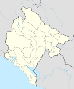
| Location of Plav in Montenegro | ||
| Coordinates: 42°36′N 19°56′E / 42.6°N 19.94°ECoordinates: 42°36′N 19°56′E / 42.6°N 19.94°E | ||
| Country | Montenegro | |
| Settlements | 23 | |
| Government | ||
| • Mayor | Skender Šarkinović (DPS) | |
| • Ruling party | DPS - BS | |
| Area | ||
| • Total | 486 km2 (188 sq mi) | |
| Population (2003 census) | ||
| • Total | 3,615 | |
| • Density | 28/km2 (70/sq mi) | |
| • Municipality | 13,805 | |
| Time zone | CET (UTC+1) | |
| • Summer (DST) | CEST (UTC+2) | |
| Postal code | 84325 | |
| Area code | +382 51 | |
| ISO 3166-2 code | ME-13 | |
| Car plates | PL | |
Plav (Montenegrin Cyrillic: Плав, pronounced [plâv̞]) is a town in north-eastern Montenegro. It has a population of 3,615 (2003 census).
Plav is the centre of Plav Municipality (population of 13,805).
The name Plav (Плав) is derived from Slavic plav, "a flooded place" (poplava, "flood"). In Albanian it is known as Plava.
Plav is located at the foot of the Prokletije mountain range, adjacent to the springs of the river Lim.
The area contains many lakes and the most known is Lake Plav, one of the largest in this region. The lakes Hrid and Visitor are mountain lakes, and Visitor is noted for its floating island.
Plav is also renowned for its karst wells, among which are Ali Pasha of Gucia Springs and Oko Skakavica. Villages in the municipality include Gusinje.
In the Middle Ages, there was a župa (district) named Plav at the source of the flow of the Lim river and around the Plav lake. It is mentioned in several medieval Serbian documents.
The settlement of Plav itself was founded by the Ottoman Empire. The Ottoman census organised in 1582-83 registered the Plav nahiyah within the Sanjak of Scutari with 18 villages; according to historian Milan Vasić all inhabitants had personal names with a Serbian character, and no Muslims were present.
...
Wikipedia


