Plaistow, Newham
| Plaistow | |
|---|---|
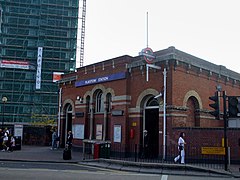
 Plaistow District line underground station |
|
 Plaistow Road/ High Street, Upper Road |
|
| Plaistow shown within Greater London | |
| Population | 31,874 (2011 Census. Plaistow North and South Wards) |
| OS grid reference | TQ405825 |
| London borough | |
| Ceremonial county | Greater London |
| Region | |
| Country | England |
| Sovereign state | United Kingdom |
| Post town | LONDON |
| Postcode district | E13 |
| Dialling code | 020 |
| Police | Metropolitan |
| Fire | London |
| Ambulance | London |
| EU Parliament | London |
| UK Parliament | |
| London Assembly | |
Plaistow (/ˈplɑːstoʊ/ PLAHST-oh or /ˈplæstoʊ/ PLAST-oh) is a district in the West Ham area of the London Borough of Newham in east London, England. It forms the majority of the London E13 postcode district.
Plaistow is a residential area, including several council estates. The main roads are the A112, Prince Regent Lane/ Greengate Street/ The Broadway/ High Street/ Plaistow Road, which is a former Roman road, and the A124 (Barking Road), which passes south west/ north east through Plaistow and past the former West Ham United football ground. Commercial and retail premises are on the A112 at Greengate Street leading north and Prince Regent Lane south, leading 0.3 miles (0.48 km) to Newham Sixth Form College and along the A124. It contains generally smaller shops compared to Stratford or West Ham.
...
Wikipedia

