Plaisance, Quebec
| Plaisance | |
|---|---|
| Municipality | |

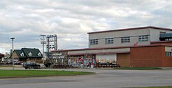
Plaisance cheese factory
|
|
 Location within Papineau RCM. |
|
| Location in western Quebec. | |
| Coordinates: 45°37′N 75°07′W / 45.617°N 75.117°WCoordinates: 45°37′N 75°07′W / 45.617°N 75.117°W | |
| Country |
|
| Province |
|
| Region | Outaouais |
| RCM | Papineau |
| Constituted | October 31, 1900 |
| Government | |
| • Mayor | Paulette Lalande |
| • Federal riding | Argenteuil—Papineau—Mirabel |
| • Prov. riding | Papineau |
| Area | |
| • Total | 50.20 km2 (19.38 sq mi) |
| • Land | 36.23 km2 (13.99 sq mi) |
| Population (2011) | |
| • Total | 1,103 |
| • Density | 30.4/km2 (79/sq mi) |
| • Pop 2006-2011 |
|
| • Dwellings | 514 |
| Time zone | EST (UTC−5) |
| • Summer (DST) | EDT (UTC−4) |
| Postal code(s) | J0V 1S0 |
| Area code(s) | 819 |
| Highways |
|
| Website | www |
Plaisance is a municipality in Papineau Regional County Municipality in western Quebec, Canada. The village is situated on the Ottawa River near the mouth of the Petite-Nation River, 70 km from Gatineau and 160 km from Montreal on Route 148.
The village is well known for its waterfalls located just north of town as well as a local cheese factory which was previously quite popular in the Outaouais region. There is also the Plaisance National Park, a large bird reserve between the main highway and the Ottawa River.
Population trend:
Private dwellings (occupied by usual residents): 471
Languages:
According to the Canada 2001 Census:
...
Wikipedia

