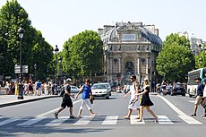
Place Saint-Michel

The place Saint-Michel and the fontaine Saint-Michel, Paris
|
|
| Length | 140 m (460 ft) |
|---|---|
| Width | 28 m (92 ft) |
| Arrondissement | 5th, 6th |
| Quarter | Quartier Latin |
| Construction | |
| Completion | 1855 |
| Denomination | Saint-Michel |
Coordinates: 48°51′12″N 2°20′38″E / 48.85333°N 2.34389°E
The Place Saint-Michel is a public square in the Latin Quarter, on the borderline between the fifth and sixth arrondissements of Paris, France. It lies on the left bank of the river Seine facing the Île de la Cité, to which it is linked by the Pont Saint-Michel.
The northern end of the Place Saint-Michel, the end closer to the river, is on the left-bank side of the Pont Saint-Michel, which crosses sixty-two metres of water to reach the island, Île de la Cité. At this point, the Place Saint-Michel is formed by the convergence of four streets: two quais along the Seine, the Quai Saint-Michel and the Quai des Grands-Augustins, and the Boulevard Saint-Michel and the Rue Danton, which arrive at angles.
As one proceeds southward along the Rue Danton, addresses on either side of the street are 'Place Saint-Michel' addresses. This continues until one approaches the Rue Saint-André des Arts, which enters from the right, when the addresses become 'Place Saint-André des Arts' addresses. Only south of this place, is the name, Rue Danton, applied. So, one may suppose that the southern end of the Place Saint-Michel is on the street that becomes Rue Danton, about sixty metres north of the intersection with the Rue Saint-André des Arts.
...
Wikipedia

