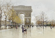
Place Charles de Gaulle, Paris
 |
|
| Length | 240 m (790 ft) |
|---|---|
| Width | 240 m (790 ft) |
| Arrondissement | 8th, 16th, 17th |
| Quarter | Champs Elysées, Faubourg du Roule, Chaillot, Ternes. |
| Construction | |
| Completion | 1670 |
| Denomination | 13 November 1970 |
The Place Charles de Gaulle, historically known as the Place de l'Étoile (pronounced: [plas də letwal]), is a large road junction in Paris, France, the meeting point of twelve straight avenues (hence its historic name, which translates as "Square of the Star") including the Champs-Élysées. It was renamed in 1970 following the death of General and President Charles de Gaulle. It is still often referred to by its original name, and the nearby metro station retains the designation Charles de Gaulle – Étoile.
Paris Axe historique ("historical axis") cuts through the Arc de Triomphe, which stands at the centre of the Place de l'Étoile.
The original name of the area was the Butte Chaillot ("Chaillot mound", named after the locality). At the time it was the point of convergence of several hunting trails. The Marquis de Marigny constructed monumental roadworks, completed in 1777, on the mound when he was establishing the plantations along the Champs Élysées. This work included paving of the road in the form of a star, as it still exists today. The junction became known as the Place de l'Étoile. Pedestrian access to the Arc de Triomphe itself is via pedestrian underpass, to avoid the confluence of vehicular traffic from the juncture of twelve radiating twelve avenues.
In 1787, during the construction of the Farmers-General Wall (Mur des Fermiers généraux), la Barrière de l'Étoile (also known as the Barrière de Neuilly) was built to the design of Claude Nicolas Ledoux for the collection of the octroi tax at the entrance to Paris. The wall and the two buildings built on either side of the Place de l'Étoile were demolished in the nineteenth century.
...
Wikipedia

