Piura Region
| Piura Region | |
|---|---|
| Region | |

Illescas Peninsula
|
|
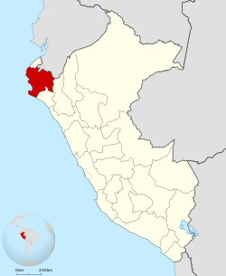
 Location of the Piura Region in Peru |
|
| Coordinates: 4°59′S 80°25′W / 4.99°S 80.41°WCoordinates: 4°59′S 80°25′W / 4.99°S 80.41°W | |
| Country | Peru |
| Subdivisions | 8 provinces and 64 districts |
| Capital | Piura |
| Government | |
| • President | César Trelles Lara |
| Area | |
| • Total | 35,892.49 km2 (13,858.17 sq mi) |
| Elevation(Capital) | 29 m (95 ft) |
| Highest elevation | 2,709 m (8,888 ft) |
| Lowest elevation | -34 m (−112 ft) |
| Population (2005 Census) | |
| • Total | 1,630,772 |
| • Density | 45/km2 (120/sq mi) |
| UBIGEO | 20 |
| Dialing code | 073 |
| ISO 3166 code | PE-PIU |
| Principal resources | Petroleum, rice, cotton, lemon |
| Poverty rate | 63.3% |
| Percentage of Peru's GDP | 3.94% |
| Website | www.regionpiura.gob.pe |
Piura is a coastal region in northwestern Peru. The region's capital is Piura and its largest port cities, Paita and Talara, are also among the most important in Peru. The area is known for its tropical and dry beaches.
The country's latest decentralization program is in hiatus after the proposal to merge departments was defeated in the national referendum in October 2005. The referendum held on October 30, 2005, as part of the ongoing decentralization process in Peru, to decide whether the region would merge with the current regions of Lambayeque and Tumbes to create a new Región Norte was defeated.
The Piura Region is bordered to the north by the Tumbes Region and Ecuador, to the east by Cajamarca Region, to the south by the Lambayeque Region, and to the west by the Pacific Ocean. "Punta Pariñas" in Piura is South America's most western point.
The territory of the Piura Region has many climate variations due to its geographical location. It is just 4 degrees south of the equator, yet receives two ocean currents at the same time: the cold Humboldt Current (13-20 °C 55-68 F) and the warm El Niño Current (20-27 °C, 68-80 F). This makes the Piura Region a land that is both tropical and arid at the same time, The Land where the Tropics meets The Desert
The coast is divided by the Peruvian subtropical desert of Sechura on the south and savanna-like scrub tropical dry forests to the center and north of the region. There are also small valleys of tropical climate, where rice and coconut fields are common, especially around the Piura and Sullana rivers.
...
Wikipedia
