Pittsfield, New Hampshire
| Pittsfield, New Hampshire | ||
|---|---|---|
| Town | ||

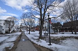
Town green
|
||
|
||
| Motto: "The Gem of the Suncook Valley" | ||
 Location in Merrimack County and the state of New Hampshire |
||
| Coordinates: 43°18′17″N 71°19′42″W / 43.30472°N 71.32833°WCoordinates: 43°18′17″N 71°19′42″W / 43.30472°N 71.32833°W | ||
| Country | United States | |
| State | New Hampshire | |
| County | Merrimack | |
| Incorporated | 1782 | |
| Government | ||
| • Board of Selectmen | Larry Konopka, Chair Gerard LeDuc Carl Anderson Carole Richardson Jim Allard |
|
| Area | ||
| • Total | 24.1 sq mi (62.5 km2) | |
| • Land | 23.9 sq mi (61.8 km2) | |
| • Water | 0.3 sq mi (0.7 km2) 1.13% | |
| Elevation | 525 ft (160 m) | |
| Population (2010) | ||
| • Total | 4,106 | |
| • Density | 170/sq mi (66/km2) | |
| Time zone | Eastern (UTC-5) | |
| • Summer (DST) | Eastern (UTC-4) | |
| ZIP code | 03263 | |
| Area code(s) | 603 | |
| FIPS code | 33-61940 | |
| GNIS feature ID | 0873699 | |
| Website | www |
|
Pittsfield is a town in Merrimack County, New Hampshire, United States. The population was 4,106 at the 2010 census.
The central village in town, where 1,576 people resided at the 2010 census, is defined as the Pittsfield census-designated place (CDP), and is located on the Suncook River near the junction of New Hampshire routes 28 and 107.
For many years prior to its 1782 incorporation, this town was an unnamed parish of Chichester. Like Pittsburg in the north, Pittsfield was named for William Pitt, Prime Minister of the United Kingdom, and a great friend of the Colonies prior to the American Revolution. The town was settled in 1768 by several families originally from Hampton. Founder John Cram built grist and sawmills here in the late 18th century. Since 1901, Globe Manufacturing has made protective clothing for firefighters here.
The town claimed the Guinness World Record in July, 2001, as the place where the most number of people wore Groucho Marx glasses at the same time (522). Before Pittsfield's attempt, no other town had tried to set the record.
According to the United States Census Bureau, the town has a total area of 24.1 square miles (62 km2), of which 23.9 sq mi (62 km2) is land and 0.3 sq mi (0.78 km2) is water, comprising 1.13% of the town. Pittsfield is drained by the Suncook River. The highest point in town is the summit of Catamount Mountain, at 1,331 feet (406 m) above sea level, southeast of the town center.
...
Wikipedia

