Pitkin County, Colorado
| Pitkin County, Colorado | |
|---|---|

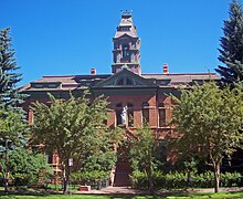
Pitkin County Courthouse
|
|
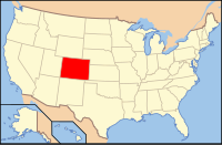
 Location in the U.S. state of Colorado |
|
 Colorado's location in the U.S. |
|
| Founded | February 23, 1881 |
| Named for | Frederick Walker Pitkin |
| Seat | Aspen |
| Largest city | Aspen |
| Area | |
| • Total | 973 sq mi (2,520 km2) |
| • Land | 971 sq mi (2,515 km2) |
| • Water | 2.5 sq mi (6 km2), 0.3% |
| Population (est.) | |
| • (2015) | 17,787 |
| • Density | 18/sq mi (7/km²) |
| Congressional district | 3rd |
| Time zone | Mountain: UTC-7/-6 |
| Website | www |
Pitkin County is one of the 64 counties in the U.S. state of Colorado. As of the 2010 census, the population was 17,148. The county seat is Aspen. The county is named in honor of the late Colorado Governor Frederick Walker Pitkin. Pitkin County has the seventh-highest per capita income of any county in the United States.
Pitkin County is included in the Glenwood Springs, CO Micropolitan Statistical Area, which is also included in the Edwards-Glenwood Springs, CO Combined Statistical Area.
According to the U.S. Census Bureau, the county has a total area of 973 square miles (2,520 km2), of which 971 sq mi (2,510 km2) is land and 2.5 sq mi (6.5 km2) (0.3%) is water. The high point of the county is Castle Peak, a fourteener with a height of 14,265 feet (4,348 m). It is located 20 miles (32 km) south of Aspen on the Gunnison County border.
As of the census of 2000, there were 14,872 people, 6,807 households, and 3,185 families residing in the county. The population density was 15 people per square mile (6/km²). There were 10,096 housing units at an average density of 10 per square mile (4/km²). The racial makeup of the county was 94.33% White, 0.53% Black or African American, 0.27% Native American, 1.12% Asian, 0.04% Pacific Islander, 2.37% from other races, and 1.34% from two or more races. Of the population, 6.54% were Hispanic or Latino of any race.
...
Wikipedia
