Pirbright
| Pirbright | |
|---|---|
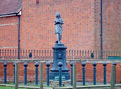
 Statue near Pirbright village hall |
|
 The Basingstoke Canal divides the communities of Pirbright |
|
| Pirbright shown within Surrey | |
| Area | 19.01 km2 (7.34 sq mi) |
| Population | 3,691 (Civil Parish 2011) |
| • Density | 194/km2 (500/sq mi) |
| OS grid reference | SU950550 |
| Civil parish |
|
| District | |
| Shire county | |
| Region | |
| Country | England |
| Sovereign state | United Kingdom |
| Post town | Woking |
| Postcode district | GU24 |
| Dialling code | 01483 |
| Police | Surrey |
| Fire | Surrey |
| Ambulance | South East Coast |
| EU Parliament | South East England |
| UK Parliament | |
Pirbright /pɜːrbraɪt/ is a village in Surrey, England. Pirbright is in the borough of Guildford and has a civil parish council covering the traditional boundaries of the area. Pirbright contains one buffered sub-locality, Stanford Common near the nation's farm animal disease research institute. Explorer Henry Morton Stanley has his imposing boulder grave at the end of the grounds of the grade II* listed medieval church. The nearby Hodge Brook is marked as Congo Stream, between Ruwenzori and Stanley Hills.
Pirbright has two communities: army training barracks and designated homes are north of a London main axis (south-west) railway and the slightly dispersed village is south. The village is almost entirely surrounded by heathland, much of it owned by the Ministry of Defence and used by the Army Training Centre, Pirbright. The south and south-east of the parish is mostly woodland and has three small farms. The south-west of the parish has a large military training area, Pirbright Common. Near to the church are several features due to Stanley's association with the village: Hodge Brook is equally marked as Congo Stream, between Ruwenzori Hill and Stanley Hill. Mazamboni Farm is next to Aruwimi Wood.
Its name had three medieval variants (each involving the letter 'f' where there is currently a 'b'). It came from Anglo-Saxon (Old English) Pirige-fyrhþ = "sparse woodland where peartrees grow".
...
Wikipedia

