Piqua, Ohio
| Piqua, Ohio | |
|---|---|
| City | |

Aerial view of Piqua
|
|
| Motto: "Where Vision becomes reality" | |
 Location of Piqua, Ohio |
|
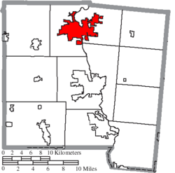
 Location of Piqua in Miami County |
|
| Coordinates: 40°8′51″N 84°14′53″W / 40.14750°N 84.24806°WCoordinates: 40°8′51″N 84°14′53″W / 40.14750°N 84.24806°W | |
| Country | United States |
| State | Ohio |
| County | Miami |
| Government | |
| • Mayor | Kathryn Hinds |
| Area | |
| • Total | 11.89 sq mi (30.79 km2) |
| • Land | 11.62 sq mi (30.10 km2) |
| • Water | 0.27 sq mi (0.70 km2) |
| Elevation | 873 ft (266 m) |
| Population (2010) | |
| • Total | 20,522 |
| • Estimate (2012) | 20,619 |
| • Density | 1,766.1/sq mi (681.9/km2) |
| Time zone | Eastern (EST) (UTC-5) |
| • Summer (DST) | EDT (UTC-4) |
| ZIP code | 45356 |
| Area code(s) | 937 |
| FIPS code | 39-62848 |
| GNIS feature ID | 1061544 |
| Website | http://www.piquaoh.org/ |
Piqua /ˈpɪkwə/ PIK-wə is a city in Miami County, Ohio, United States. The population was 20,522 at the 2010 census. It is part of the Dayton Metropolitan Statistical Area.
Piqua was one of the cities that suffered severe flooding during the Great Dayton Flood of 1913.
In 1747, Fort Pickawillany was constructed by the British to protect their trading post at a Miami village of the same name. It was located at the confluence of Loramie Creek and the Great Miami River. (The present city of Piqua developed about a mile to the southwest.) In 1752 Charles de Langlade, an Ottawa war chief of partial French Canadian descent, attacked the fort. He led more than 240 Ottawa and Ojibwe warriors allied with French forces against the British and the Miami village in the Battle of Pickawillany. The Miami chief and a British trader were killed in the conflict.
After the battle, the British and Miami abandoned this site. The Miami rebuilt Pickawillany, and Piqua later developed near their village. The British soon took over the area after defeating the French in the Seven Years' War (1754-1763), known in British North America as the French and Indian War.
...
Wikipedia
