Pilot Butte, Saskatchewan
| Pilot Butte | ||
|---|---|---|
| Town | ||
| Town of Pilot Butte | ||

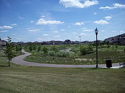
Park on Pilot Butte Creek
|
||
|
||
| Motto: "The Town That Cares" | ||
| Location of Pilot Butte in Saskatchewan | ||
| Coordinates: 50°28′N 104°25′W / 50.467°N 104.417°WCoordinates: 50°28′N 104°25′W / 50.467°N 104.417°W | ||
| Country |
|
|
| Province |
|
|
| Settled | 1882 | |
| Incorporated (village) | 1913 | |
| Incorporated (town) | 1979 | |
| Government | ||
| • Mayor | Peggy Chorney | |
| • Town Administrator | Brandi Morissette | |
| • Governing body | Pilot Butte Town Council | |
| • MLA Indian Head-Milestone | Don McMorris | |
| • MP Regina-Qu'Appelle | Andrew Scheer | |
| Area | ||
| • Town | 5.05 km2 (1.95 sq mi) | |
| Elevation | 610 m (2,000 ft) | |
| Population (2016) | ||
| • Town | 2,183 | |
| • Density | 430/km2 (1,100/sq mi) | |
| • Metro | 2,615 | |
| Time zone | Saskatchewan (ST) (UTC-6) | |
| Postal code | S0G 3Z0 | |
| Area code(s) | 306 | |
| Highways |
|
|
| Website | Official Website | |
Pilot Butte is a town of over 2100 people located in the White Butte area between Highway 46 and the Trans-Canada Highway. The town is the 15th most populated town in the province, and the 31st largest community, the town is a neighbour to White City and Balgonie. Pilot Butte is surrounded by the Rural Municipality of Edenwold No. 158 Pilot Butte, meaning "Lookout Point", was chosen in 1883 as the name for the settlement. The origin of the community name is derived from the flat-topped hill that served as a lookout for hunting buffalo (the Butte).
The Butte played a significant role in the lives of the Prairie Indians. Aboriginal people, who camped near Boggy Creek, used the Butte as a lookout and signal point.
European settlement in the area can be traced back to the 1840s. With the construction of the railway through the region in 1882, the area’s sand and gravel deposits were extensively utilized, and in the following years, as settlers began farming in the district, Pilot Butte developed. For a long time of its history, Pilot Butte was known as the "Sand Capital of Canada". Because of its location on the main line of the Canadian Pacific Railway, significant settlement took place between 1880 and 1900. Sand and gravel deposits nearby were used during the construction of the railway. The history of Pilot Butte is marked by dramatic growth followed by decline and now by growth. Except for one or two houses on Railway Avenue, the most notable being the "Martin House", there are very few physical reminders of Pilot Butte's early development. Most of the original structures, one of the most prominent being the old Canadian Pacific Railway (CPR) water tower, have either been dismantled or destroyed.
By 1913 Pilot Butte was a village. It flourished as it offered the Canadian Pacific Railway a reliable year round water source and at one point, the CPR built a water conduit to Regina. Between 1913-23, with a population of about a 1,000, Pilot Butte thrived. The town boasted a railway station, 3 grain elevators, a stockyard, the Kitchener Hotel and boarding houses. It had a pool hall, bowling alley, general store, butcher and blacksmith shops, 2 churches, 2 schools (nearby) and 2 section houses. Brickyards became major local employers; the brickyards closed during World War I however, and with automobiles facilitating easy transportation into Regina, Pilot Butte began to lose its population—a trend that would continue for years. In 1923, the village was disbanded owing to the loss of residents.
...
Wikipedia


