Pike Township, Warren County, Indiana
| Pike Township | |
|---|---|
| Township | |
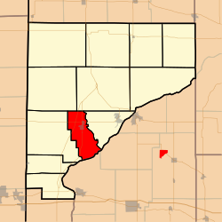
 Location of Pike Township in Warren County |
|
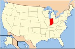
 Location of Indiana in the United States |
|
| Coordinates: 40°15′21″N 87°23′20″W / 40.25583°N 87.38889°WCoordinates: 40°15′21″N 87°23′20″W / 40.25583°N 87.38889°W | |
| Country | United States |
| State | Indiana |
| County | Warren |
| Government | |
| • Type | Indiana township |
| Area | |
| • Total | 17.56 sq mi (45.5 km2) |
| • Land | 17.36 sq mi (45.0 km2) |
| • Water | 0.2 sq mi (0.5 km2) 1.14% |
| Elevation | 659 ft (201 m) |
| Population (2010) | |
| • Total | 1,221 |
| • Density | 70.3/sq mi (27.1/km2) |
| Time zone | Eastern (EST) (UTC-5) |
| • Summer (DST) | EDT (UTC-4) |
| Area code(s) | 765 |
| GNIS feature ID | 453737 |
| West Lebanon, Indiana | ||||||||||||||||||||||||||||||||||||||||||||||||||||||||||||
|---|---|---|---|---|---|---|---|---|---|---|---|---|---|---|---|---|---|---|---|---|---|---|---|---|---|---|---|---|---|---|---|---|---|---|---|---|---|---|---|---|---|---|---|---|---|---|---|---|---|---|---|---|---|---|---|---|---|---|---|---|
| Climate chart () | ||||||||||||||||||||||||||||||||||||||||||||||||||||||||||||
|
||||||||||||||||||||||||||||||||||||||||||||||||||||||||||||
|
||||||||||||||||||||||||||||||||||||||||||||||||||||||||||||
| J | F | M | A | M | J | J | A | S | O | N | D |
|
1.9
32
15
|
1.8
38
20
|
2.8
49
29
|
3.4
62
39
|
4.3
73
50
|
4.5
82
60
|
4.2
85
63
|
3.7
83
60
|
3.1
77
52
|
2.8
65
41
|
3.2
50
33
|
2.5
37
21
|
| Average max. and min. temperatures in °F | |||||||||||
| Precipitation totals in inches | |||||||||||
| Source: The Weather Channel | |||||||||||
| Metric conversion | |||||||||||
|---|---|---|---|---|---|---|---|---|---|---|---|
| J | F | M | A | M | J | J | A | S | O | N | D |
|
49
0
−9
|
46
3
−7
|
72
9
−2
|
86
17
4
|
108
23
10
|
115
28
16
|
106
29
17
|
93
28
16
|
77
25
11
|
...
| ||
