Pico-Union, Los Angeles
| Pico-Union | |
|---|---|
| Neighborhood of Los Angeles | |

The historic Doria Apartments in Pico-Union
|
|
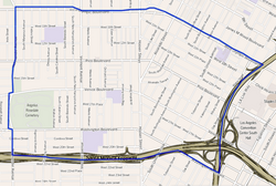
 Map of the Pico-Union neighborhood of Los Angeles, as delineated by the Los Angeles Times |
|
| Location within Central Los Angeles | |
| Coordinates: 34°2′41″N 118°16′37″W / 34.04472°N 118.27694°WCoordinates: 34°2′41″N 118°16′37″W / 34.04472°N 118.27694°W |
Pico-Union is a densely populated, low-income, youthful, 85.4% Latino, mostly native neighborhood in Central Los Angeles, California. Historic in character and undergoing a renewal program, the neighborhood is home to two high schools and seven other schools, as well as a branch public library. It is the site of the long-established private Angelus-Rosedale Cemetery.
Pico-Union is flanked by Koreatown and Westlake to the north and northeast, Downtown to the east, Adams-Normandie, University Park and Exposition Park to the south and Harvard Heights to the west.
The neighborhood is bounded on the north and northeast by Olympic Boulevard, on the east by the 110 Freeway, on the south by the Santa Monica Freeway and on the west by Normandie Avenue. It also includes the California Highway Patrol station beneath the freeway interchange northeast of Washington Boulevard.
Relation of Pico-Union to other communities:
The area encompassed by Pico-Union was developed as a middle and upper middle class residential district beginning in the 1910s. Easy access to downtown Los Angeles and the nearby Wilshire District drew large numbers of affluent homeowners. Following the Second World War, the Pico-Union area, like many inner city neighborhoods, experienced an outflux of residents to the suburbs. The loss of residents and business led to high vacancy rates and lower property values in much of the neighborhood by the 1960s.
...
Wikipedia

