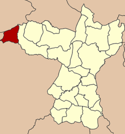
Phu Pha Man District
|
Phu Pha Man ภูผาม่าน |
|
|---|---|
| Amphoe | |
 Amphoe location in Khon Kaen Province |
|
| Coordinates: 16°38′42″N 101°54′14″E / 16.64500°N 101.90389°ECoordinates: 16°38′42″N 101°54′14″E / 16.64500°N 101.90389°E | |
| Country |
|
| Province | Khon Kaen |
| Seat | Phu Pha Man |
| Area | |
| • Total | 284.6 km2 (109.9 sq mi) |
| Population (2005) | |
| • Total | 22,229 |
| • Density | 78.1/km2 (202/sq mi) |
| Time zone | THA (UTC+7) |
| Postal code | 40350 |
| Geocode | 4020 |
Phu Pha Man (Thai: ภูผาม่าน, pronounced [pʰūː pʰǎː mâːn]) is the northwesternmost district (Amphoe) of Khon Kaen Province, northeastern Thailand.
The district was established as a minor district (King Amphoe) on July 15, 1981 with the two tambon Non Don and Na Fai split off from Chum Phae district. The administration started operation on September 1, 1981, and on October 1, 1981 the district office building was opened. On July 4, 1994 the minor district was upgraded to a full district.
Neighboring districts are (from the north clockwise) Phu Kradueng of Loei Province, Chum Phae of Khon Kaen Province, Khon San of Chaiyaphum Province and Nam Nao of Phetchabun Province.
The district is subdivided into 5 subdistricts (tambon), which are further subdivided into 41 villages (muban). Phu Pha Man is a township (thesaban tambon) which covers parts of tambon Phu Pha Man and Non Dong. There are further 5 Tambon administrative organizations (TAO).
...
Wikipedia
