Photike
|
Paramythia Παραμυθιά |
|
|---|---|

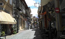
Central street of Paramythia
|
|
| Coordinates: 39°28′N 20°30′E / 39.467°N 20.500°ECoordinates: 39°28′N 20°30′E / 39.467°N 20.500°E | |
| Country | Greece |
| Administrative region | Epirus |
| Regional unit | Thesprotia |
| Municipality | Souli |
| • Municipal unit | 342.2 km2 (132.1 sq mi) |
| Population (2011) | |
| • Municipal unit | 7,459 |
| • Municipal unit density | 22/km2 (56/sq mi) |
| Community | |
| • Population | 2,730 (2011) |
| Time zone | EET (UTC+2) |
| • Summer (DST) | EEST (UTC+3) |
| Postal code | 462 00 |
| Area code(s) | 26660 |
| Vehicle registration | ΗΝΑ - ΗΝΒ - ΙΕ |
| Website | www.dimos-souliou.gr |
Paramythia (Greek: Παραμυθιά, Paramythiá) is a town and a former municipality in Thesprotia, Epirus, Greece. Since the 2011 local government reform it is part of the municipality Souli, of which it is the seat and a municipal unit. The municipal unit has an area of 342.197 km2. The town's population is 2,730 as of the 2011 census.
Paramythia acts as a regional hub for several small villages in the Valley of Paramythia, and features shops, schools, a gym, a stadium and a medical center. Primary aspects of the economy are agriculture and trade. The town is build on the slopes of Mount Gorilla and overlooks the valley, below. The Castle of Paramythia was built on a hill in one of the highest points of the town during the Byzantine period and today is open to the tourists.
The modern Egnatia Highway which links Igoumenitsa with Ioannina, goes through the valley, north of the town of Paramythia.
The name "Paramythia" derives from one of the Virgin Mary's names in Greek ("Paramythia" in Greeks means comforter). During the Byzantine era the town was also known as Agios Donatos (Greek: Άγιος Δονάτος), after Saint Donatus of Evorea, the town's patron saint. This is also the basis of the Albanian and the Turkish name of Paramythia, Ajdhonat, Ajdonat, Ajdonati and Aydonat.
The Paramythia municipal unit consists of 23 communities. The total population of the municipal unit is 7,459 (2011). The town of Paramythia itself has a population of 2,730 and lies in an amphitheatre at an altitude of 750 m, at the foot of Mount Gorilla, between the Acheron and the Kalamas rivers. The Gorilla range (altitude 1,658 m) lies on the eastern side of the city and the Chionistra (1,644 m) to the Northeast. At the city limits is the Kokytos (Cocytus) River, one of the rivers of the underworld in Greek mythology. Paramythia's valley is one of the largest in Thesprotia and is one of the major agricultural areas in Epirus.
...
Wikipedia


