Phatthalung Province
|
Phatthalung พัทลุง |
||
|---|---|---|
| Province | ||
 |
||
|
||
 Map of Thailand highlighting Phatthalung Province |
||
| Country |
|
|
| Capital | Phatthalung | |
| Government | ||
| • Governor | Wanchai Khongkasem (since June 2016) | |
| Area | ||
| • Total | 3,424.5 km2 (1,322.2 sq mi) | |
| Area rank | Ranked 58th | |
| Population (2014) | ||
| • Total | 520,419 | |
| • Rank | Ranked 47th | |
| • Density | 150/km2 (390/sq mi) | |
| • Density rank | Ranked 27th | |
| Time zone | ICT (UTC+7) | |
| ISO 3166 code | TH-93 | |
Phatthalung (Thai: พัทลุง, pronounced [pʰát.tʰā.lūŋ]) is one of the southern provinces (changwat) of Thailand. Neighboring provinces are (from north clockwise) Nakhon Si Thammarat, Songkhla, Satun and Trang.
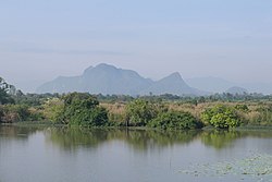
The province is on the Malay Peninsula. To the east it borders the large shallow Songkhla lake, while the west is covered by mountains of the Nakhon Si Thammarat chain. Khao Pu–Khao Ya National Park is at the border to Trang.
Phatthalung was formerly known as Mardelong (Jawi: مردلوڠ) in Malay, especially during the time when the region came under Malay-Muslim influence.
During the reign of King Ramathibodi I of the Ayutthaya kingdom in the 14th century, Phatthalung became one of twelve royal cities. At the end of the 18th century King Rama I submitted the city to the Ministry of Defense, which was responsible for all the southern provinces. During the administrative reform by King Chulalongkorn, Phatthalung became part of the Monthon Nakhon Si Thammarat.
...
Wikipedia

