Pharsalus
|
Farsala Φάρσαλα |
|
|---|---|

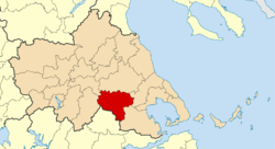
Farsala municipality map
|
|
| Coordinates: 39°18′N 22°23′E / 39.300°N 22.383°ECoordinates: 39°18′N 22°23′E / 39.300°N 22.383°E | |
| Country | Greece |
| Administrative region | Thessaly |
| Regional unit | Larissa |
| Area | |
| • Municipality | 739.7 km2 (285.6 sq mi) |
| • Municipal unit | 121.433 km2 (46.886 sq mi) |
| Elevation | 160 m (520 ft) |
| Population (2011) | |
| • Municipality | 18,545 |
| • Municipality density | 25/km2 (65/sq mi) |
| • Municipal unit | 9,982 |
| • Municipal unit density | 82/km2 (210/sq mi) |
| Community | |
| • Population | 9,337 (2011) |
| • Area (km2) | 57.928 |
| Time zone | EET (UTC+2) |
| • Summer (DST) | EEST (UTC+3) |
| Postal code | 403 00 |
| Area code(s) | 24910 |
| Vehicle registration | ΡΙ |
| Website | www.farsala.gr |
Farsala (Greek: Φάρσαλα), known in Antiquity as Pharsalos (Ancient Greek: Φάρσαλος, Latin: Pharsalus), is a city in southern Thessaly, in Greece. Farsala is located in the southern part of Larissa regional unit, and is one of its largest towns. Farsala is an economic and agricultural centre of the region. Cotton and are the main agricultural products, and many inhabitants are employed in the production of textile. Farsala is famous for its distinctive halva, but even more so for its significance in ancient history.
Farsala lies at the southern edge of the Thessalian Plain, 4 km south of the river Enipeas. The Greek National Road 3 (Larissa - Lamia) and the Greek National Road 30 (Karditsa - Volos) pass through the town. The Palaiofarsalos railway station (litt. "Ancient Pharsalus"), on the line from Athens to Thessaloniki and head of the branch line to Kalambaka, is located in the village of Stavros, 12 km to the west. Farsala is located 38 km south of Larissa, 41 km east of Karditsa, 44 km north of Lamia and 49 km west of Volos.
The municipality Farsala has an area of 739.74 km2, the municipal unit Farsala has an area of 121.433 km2, and the community Farsala has an area of 57.928 km2.
...
Wikipedia


