Petite Terre Islands

Petite Terre Lighthouse in 2010
|
|
|
Guadeloupe
|
|
| Location | Petite Terre Guadeloupe France |
|---|---|
| Coordinates | 16°10′14.4″N 61°06′33.5″W / 16.170667°N 61.109306°W |
| Year first constructed | 1840 |
| Construction | brick tower |
| Tower shape | cylibdrical tower with balcony and lantern atop a 1-storey keeper’s house |
| Markings / pattern | unpainted tower, green lantern |
| Height | 33 metres (108 ft) |
| Focal height | 26 metres (85 ft) |
| Light source | solar power |
| Range | 15 nautical miles (28 km; 17 mi) |
| Characteristic | Fl (3) W 12s. |
| Admiralty number | J5730 |
| NGA number | 14832 |
| ARLHS number | GUA-006 |
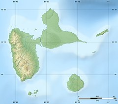
Petite Terre Islands (French: Îles de la Petite Terre, literally "Islands of the Small Land") are two small uninhabited islands located about 10 km (6.2 mi) to the south-east of the island of Grande-Terre (Guadeloupe), in the Lesser Antilles. These two islands are named Petite Terre ("Small Land") in contrast with the much larger Grande-Terre ("Large Land") island.
Petite Terre is made up of two islands: Terre de Bas island to the southwest and the smaller Terre de Haut island to the northeast. Their combined land area is 1.68 km² (168 hectares). Terre de Bas island (literally "Low Land" island or "Down Land" island) is so named because it is downwind compared to Terre de Haut island ("Upper Land" island) to its northeast which first meets the trade winds blowing from the north-east in the Caribbean.
Administratively, the Petite Terre Islands are dependent of the commune (municipality) of La Désirade. The two islands and 842 hectares (2,081 acres) of sea around them were declared a nature reserve, the National Nature Reserve of Îles de la Petite-Terre.
Coordinates: 16°10′15″N 61°6′55″W / 16.17083°N 61.11528°W
...
Wikipedia

