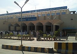
Peshawar International Airport
| Bacha Khan International Airport باچا خان بین الاقوامی ہوائی اڈا د باچا خان نړیوال هوایی ډګر |
|||||||||||
|---|---|---|---|---|---|---|---|---|---|---|---|
 |
|||||||||||
| Summary | |||||||||||
| Airport type | Public | ||||||||||
| Operator | Pakistan Civil Aviation Authority | ||||||||||
| Serves | Peshawar | ||||||||||
| Location | Khyber Pakhtunkhwa province, Pakistan | ||||||||||
| Elevation AMSL | 1,158 ft / 353 m | ||||||||||
| Coordinates | 33°59′38″N 71°30′53″E / 33.99389°N 71.51472°ECoordinates: 33°59′38″N 71°30′53″E / 33.99389°N 71.51472°E | ||||||||||
| Website | www |
||||||||||
| Map | |||||||||||
| Location of the airport in Pakistan | |||||||||||
| Runways | |||||||||||
|
|||||||||||
| Statistics (2015) | |||||||||||
|
|||||||||||
| Passengers | 1,350,121 |
|---|
Bacha Khan International Airport (IATA: PEW, ICAO: OPPS) (Urdu: باچا خان بین الاقوامی ہوائی اڈا; Pashto: د باچا خان نړیوال هوایی ډګر), previously called Peshawar International Airport ( د پېښور نړیوال هوائی ډګر ), is an international airport located in the city of Peshawar in the Khyber Pakhtunkhwa province of Pakistan. Located about a 10-minute drive from the centre of Peshawar, it is the fourth busiest airport in Pakistan. One unusual feature is that one end of the main runway is crossed by a railway line – the seldom-used Khyber train safari to Landi Kotal in the Khyber Pass. The airport was renamed on 27 January 2012 after Khan Abdul Ghaffar Khan (also known as Bacha Khan), a Pashtun nationalist political leader.
Strategically situated in the heart of Peshawar, Bacha Khan International Airport is located approximately 180 km from Islamabad (federal capital of Pakistan) which makes it about two hours drive from the capital via M-1 motorway. Since Peshawar is the capital of the Khyber Pakhtunkhwa province, it provides world connections for the majority of the northwest region of the country and adjoining areas of Afghanistan. Since the province has a large Afghan Pashtun community residing within KPK, Afghanistan flights have always been on the rise.
...
Wikipedia

