Perunchani Dam
| Perunchani Dam | |
|---|---|

Perunchani Dam
|
|
|
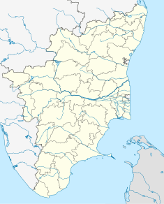
Location of Perunchani Dam in India Tamil Nadu
|
|
| Official name | Perunchani Dam |
| Country | India |
| Location | Kanyakumari District, Tamil Nadu |
| Coordinates | 8°23′4″N 77°22′28″E / 8.38444°N 77.37444°ECoordinates: 8°23′4″N 77°22′28″E / 8.38444°N 77.37444°E |
| Opening date | December 1952 |
| Owner(s) | Water Resources Organization, Government of Tamil Nadu |
| Dam and spillways | |
| Type of dam | Straight Gravity Masonry dam with concrete Spillway |
| Impounds | Paralayar River, a tributary of Tamiraparani River |
| Height | 36.27 metres (119.0 ft) above foundation |
| Length | 308 metres (1,010 ft) |
| Spillways | One |
| Spillway capacity | 894.91 m3 (31,603 cu ft) per second |
| Reservoir | |
| Creates | Perunchani Reservoir |
| Total capacity | Live storage 818,400,000 m3 (2.890×10¹⁰ cu ft) |
| Catchment area | 158.4 square kilometres (61.2 sq mi) |
Perunchani Dam is an irrigation dam at Perunchani, in Kalkulam Taluk, Kanyakumari District, in the state of Tamil Nadu, India. It is one of the dams of the Kodayar Irrigation System. As there was water deficiency in the Kodayar Irrigation System, Perunchani Dam was constructed in December 1952 to store flood water of the Paralayar River as an extension. It was built about 1 km (0.62 mi) upstream of the Puthen dam on the Paralayar River. The irrigation system became operational on 2 September 1953. It feeds the left bank irrigation canal system of the Puthen dam, which is the terminal structure of the system.
The dam is built between two hillocks (part of the Western Ghats) across the Paralayar River, a tributary of the Tamaraparani River, also known locally as the Kuzhithuraiar, and is part of the basin that constitutes the west-flowing rivers from Tadri to Kanyakumari. Tamaraparani River rises in the Western Ghats and flows through a distance of 56 km (35 mi) before debouching into the Arabian Sea. The catchment area at the Perunchani Dam site is 158.4 km2 (61.2 sq mi). The reservoir is thickly forested and inhabited by wild animals such as tiger, elephants, and deer. The tribal community of Kanikars resides around the periphery of the reservoir.
The dam is located about 43 km (27 mi) from Nagercoil, the administrative headquarters-town of Kanyakumari District, and about 10 km (6.2 mi) from the town of Kulasekharam.
The average annual rainfall in the catchment is 2,240 mm (88 in), and the average annual yield at the dam site is 218,000,000 m3 (7.7×10⁹ cu ft).
The dam was constructed between 1948–1953 by the then State of Travancore-Cochin. The height of the straight gravity masonry dam above the deepest foundation is 36.27 m (119.0 ft), with Full Reservoir Level (FRL) at 93.3 m (306 ft), which is also the Maximum Water Level (MWL). The dam is 308 m (1,010 ft) long. The gross storage capacity of the reservoir is 818,400,000 m3 (2.890×10¹⁰ cu ft) at the FRL, which is also the effective storage capacity. The reservoir area is 9,620 ha (23,800 acres). The spillway, with its crest at 88.7 m (291 ft), is designed to pass a discharge of 894.91 m3 (31,603 cu ft) per second. There are four spillway gate openings, each 12.19 m × 4.57 m (40.0 ft × 15.0 ft) in size. The total volume of material content in the dam is 51,000 m3 (1,800,000 cu ft). The project lies in Seismic Zone-III. The dam is provided with drainage gallery of 45.7 m (150 ft) length in the central section of the river. It serves the purpose of collecting seepage water from the foundation of the dam and also as an inspection gallery, and measures 1.52 m × 2.29 m (5 ft 0 in × 7 ft 6 in).
...
Wikipedia

