Pepperell, MA
| Pepperell, Massachusetts | ||
|---|---|---|
| Town | ||

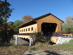
Pepperell Covered Bridge
|
||
|
||
 Location in Middlesex County in Massachusetts |
||
| Coordinates: 42°39′57″N 71°35′20″W / 42.66583°N 71.58889°WCoordinates: 42°39′57″N 71°35′20″W / 42.66583°N 71.58889°W | ||
| Country | United States | |
| State | Massachusetts | |
| County | Middlesex | |
| Settled | 1720 | |
| Incorporated | 1775 | |
| Government | ||
| • Type | Open town meeting | |
| Area | ||
| • Total | 23.2 sq mi (60.0 km2) | |
| • Land | 22.6 sq mi (58.4 km2) | |
| • Water | 0.6 sq mi (1.6 km2) | |
| Elevation | 244 ft (74 m) | |
| Population (2010) | ||
| • Total | 11,497 | |
| • Density | 500/sq mi (190/km2) | |
| Time zone | Eastern (UTC-5) | |
| • Summer (DST) | Eastern (UTC-4) | |
| ZIP code | 01463 | |
| Area code(s) | 351 / 978 | |
| FIPS code | 25-52805 | |
| GNIS feature ID | 0618231 | |
| Website | town.pepperell.ma.us | |
Pepperell is a town in Middlesex County, Massachusetts, United States. The population was 11,497 at the 2010 census. It includes the village of East Pepperell.
Pepperell was first settled in 1720 as a part of Groton, and was officially incorporated as its own town in 1775. The founders named it after Sir William Pepperrell, a Massachusetts colonial soldier who led the Siege of Louisbourg during King George's War. The town was noted for its good soil and orchards.
Since its formation, the town was active in the American independence movement. Being located northwest of Concord, Pepperell never saw British attack during the American Revolutionary War, though several Pepperell men fought at the Old North Bridge during the Battle of Concord, and a British spy was captured by women on guard at the site of the Pepperell covered bridge. Town resident William Prescott served as the commander at the Battle of Bunker Hill in what is now the Charlestown neighborhood of Boston.
By 1837, when the population was 1,586, Pepperell had three paper mills, one of which was managed by Warren F. Daniell. It also produced palm leaf hats, boots and shoes.
...
Wikipedia

