Pelham, New York
| Pelham | |
|---|---|
| Town | |
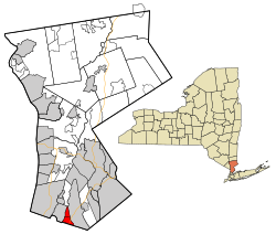
 Location of Pelham, New York |
|
| Coordinates: 40°54′38″N 73°48′27″W / 40.91056°N 73.80750°W | |
| Country | United States |
| State | New York |
| County | Westchester; Bronx |
| Incorporated | 1788 |
| Government | |
| • Town Supervisor | Peter DiPaola (D) (2016) |
| Area | |
| • Total | 2.2 sq mi (5.7 km2) |
| • Land | 2.2 sq mi (5.6 km2) |
| • Water | 0.04 sq mi (0.1 km2) 2.27% |
| Elevation | 63.1 ft (19.2 m) |
| Population (2010 Census) | |
| • Total | 12,396 |
| • Density | 5,600/sq mi (2,200/km2) |
| Time zone | Eastern |
| ZIP code | 10803 |
| Area code(s) | 914 |
| Website | http://www.townofpelham.com/ |
Pelham /pɛləm/ is a suburban town in Westchester County, New York and Bronx County, New York, approximately 10 miles northeast of Midtown Manhattan. As of the 2010 census, it had a population of 12,396. Historically, Pelham was composed of five villages and became known as "the Pelhams". Pelham currently contains two independently incorporated villages: the Villages of Pelham and Pelham Manor, Approximately 28 minutes away from Grand Central Terminal by the Metro-North train, Pelham is home to many New York City commuters and has an active social community for its residents.
According to the United States Census Bureau, the town has a total area of 2.4 square miles (6.2 km2). It is directly north of the New York City borough of the Bronx and borders Eastchester, New Rochelle and Mount Vernon.
Pelham also includes a small portion of the borough of the Bronx, commonly called "Bronx Manor", named for the borough and the village of Pelham Manor. As of the 2010 census, this small area consists of 1,444 residents living on nine residential streets: Split Rock Road, Lincoln Avenue, Ropes Avenue, McOwen Avenue, Hutchinson Avenue, Flint Avenue, Hollers Avenue, Boston Road, Pelham Bay Park West, and Good Place.
...
Wikipedia
