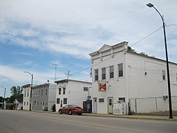
Pearl City, Illinois
| Pearl City | |
| Village | |
|
Business district in Pearl City
|
|
| Country | United States |
|---|---|
| State | Illinois |
| County | Stephenson |
| Township | Loran |
| Elevation | 833 ft (254 m) |
| Coordinates | 42°15′59″N 89°49′38″W / 42.26639°N 89.82722°WCoordinates: 42°15′59″N 89°49′38″W / 42.26639°N 89.82722°W |
| Area | 0.65 sq mi (2 km2) |
| - land | 0.64 sq mi (2 km2) |
| - water | 0.01 sq mi (0 km2) |
| Population | 838 people (2010) |
| Density | 1,376.7/sq mi (532/km2) |
| Founded | March 21, 1893 |
| Government | Trustee-Village |
| Village President | Robert Knoup |
| Postal code | 61062 |
| Area code | 815 |
Pearl City is an incorporated village in Stephenson County, Illinois, with a population of 838 at the 2010 census, up from 780 in 2000.
In the early 1840s, the village of Yellow Creek was established in southwest Stephenson County, Illinois on a creek also named Yellow Creek. Anson Andrews built a grain mill which used the power from the creek, and others soon settled near and around the mill, giving way to a small settlement. In the 1850s, the village had expanded to a size warranting its own post office, a significant addition to small midwestern settlements of the time.
In 1892, the village was renamed "Pearl City" when, a few years earlier, a young man named Daniel Ditzler found a number of fresh water pearls in the creek. In 1888, the Chicago, St. Paul and Kansas City Railroad (later renamed the Chicago Great Western Railway) reached Pearl City. With the railroad came access to cheap goods and transportation, leading to more growth in the town.
Water lines were laid in 1902, electricity arrived in 1913, and a grain elevator was established in 1918. By 1910, the population reached 300, and in 1912 a school was built. Although it has been remodeled and expanded several times, the building is still home to the Pearl City community school today. In 1926, Illinois Route 73 was surveyed and built through Pearl City.
As of the census of 2000, there were 780 people, 293 households, and 225 families residing in the village. The population density was 1,376.7 people per square mile (528.4/km²). There were 314 housing units at an average density of 554.2 per square mile (212.7/km²). The racial makeup of the village was 98.21% White, 0.38% African American, 0.13% Asian, 0.26% from other races, and 0.38% from two or more races. Hispanic or Latino of any race were 0.64% of the population.
...
Wikipedia


