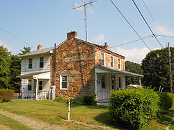
Peach Bottom Township, York County, Pennsylvania
| Peach Bottom Township, Pennsylvania | |
|---|---|
| Township | |

One of the four Coulsontown Cottages in Coulsontown
|
|
 Location in York County and the state of Pennsylvania. |
|
| Country | United States |
| State | Pennsylvania |
| County | York |
| Settled | 1735 |
| Incorporated | 1815 |
| Government | |
| • Type | Board of Supervisors |
| Area | |
| • Total | 33.5 sq mi (87 km2) |
| Population (2010) | |
| • Total | 4,813 |
| • Estimate (2016) | 4,951 |
| • Density | 140/sq mi (55/km2) |
| Time zone | Eastern (EST) (UTC-5) |
| • Summer (DST) | EDT (UTC-4) |
| Area code(s) | 717 |
| FIPS code | 42-133-58560 |
Peach Bottom Township is a township in York County, Pennsylvania, 60 miles (97 km) south of Harrisburg. The population was 4,813 at the 2010 census.
Peach Bottom Township was so named on account of peach trees growing near a river (bottom).Peach Bottom Nuclear Generating Station was built in 1958.
The Coulsontown Cottages Historic District, Delta Trestle Bridge, Maryland and Pennsylvania Railroad, and Scott Creek Bridge-North, Maryland and Pennsylvania Railroad are listed on the National Register of Historic Places.
According to the United States Census Bureau, the township has a total area of 29.6 square miles (77 km2), of which 29.2 square miles (76 km2) is land and 0.4 square miles (1.0 km2), or 1.28%, is water. The southern boundary of the township is the Maryland-Pennsylvania border (the Mason–Dixon Line), and the eastern border is the Susquehanna River. The township surrounds on three sides the borough of Delta, located along the state line.
As of the census of 2000, there were 4,412 people, 1,528 households, and 1,216 families residing in the township. The population density was 151.0 people per square mile (58.3/km²). There were 1,852 housing units at an average density of 63.4/sq mi (24.5/km²). The racial makeup of the township was 96.60% White, 1.99% African American, 0.36% Native American, 0.32% Asian, 0.09% from other races, and 0.63% from two or more races. Hispanic or Latino of any race were 0.57% of the population.
...
Wikipedia
