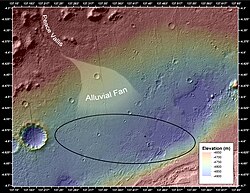
Peace Vallis

Peace Vallis and related alluvial fan near the Curosity rover landing ellipse and landing site ("Bradbury Landing") (noted by +).
|
|
| Coordinates | 4°13′S 137°14′E / 4.21°S 137.23°ECoordinates: 4°13′S 137°14′E / 4.21°S 137.23°E |
|---|---|
| Length | 35.24 km (21.90 mi) |
| Naming | adopted by the IAU on September 26, 2012 after a "River in British Columbia and Alberta, Canada". |
Peace Vallis is an outflow channel in Gale Crater in the Aeolis quadrangle on the planet Mars; it appears to have been carved by fluids, perhaps water. The valley 'flows' southeast down out of the hills of Gale Crater to Aeolis Palus below near "Mount Sharp" and is centered 4°13′S 137°14′E / 4.21°S 137.23°E.Peace Vallis is near the landing site ("Bradbury Landing") of the Curiosity rover which started studying the valley in 2012. The name, Peace Vallis, was officially adopted by the IAU on September 26, 2012.
Curiosity rover landed near the end of the Peace Vallis fan. Peace Vallis fan covers 80 km2 and obtained water from an area of 730 km2. Peace Vallis enters Gale Crater through a 15 km wide gap in its rim. Calculations suggest that the fan has an average thickness of 9 m. Numerous inverted channels are visible on the western surface of the fan. Runoff through Peace Vallis that made the fan is estimated to be between 600 and 6000 m; therefore a hydrologic cycle probably lasted at least thousands of years. The water that flowed in Peace Vallis is believed to be from precipitation maybe in the form of snow.
Map of actual (and proposed) Rover landing sites including Gale Crater.
Gale Crater - Landing site is within Aeolis Palus near Aeolis Mons ("Mount Sharp") - North is down.
...
Wikipedia
