Aeolis quadrangle

Map of Aeolis quadrangle from Mars Orbiter Laser Altimeter (MOLA) data. The highest elevations are red and the lowest are blue. The Spirit rover landed in Gusev crater. Aeolis Mons is in Gale Crater.
|
|
| Coordinates | 15°00′S 202°30′W / 15°S 202.5°WCoordinates: 15°00′S 202°30′W / 15°S 202.5°W |
|---|---|
|
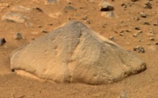
Above: An approximate true-color view of Adirondack, taken by Spirit's pancam.
Right:Digital camera image (from Spirit's Pancam) of Adirondack after a RAT grind (Spirit's rock grinding tool) |
|
| Feature type | Rock |
|---|---|
The Aeolis quadrangle is one of a series of 30 quadrangle maps of Mars used by the United States Geological Survey (USGS) Astrogeology Research Program. The Aeolis quadrangle is also referred to as MC-23 (Mars Chart-23). The Aeolis quadrangle covers 180° to 225° W and 0° to 30° south on Mars, and contains parts of the regions Elysium Planitia and Terra Cimmeria. A small part of the Medusae Fossae Formation lies in this quadrangle.
The name refers to the name of a floating western island of Aiolos, the ruler of the winds. In Homer's account, Odysseus received the west wind Zephyr here and kept it in bags, but the wind got out.
It is famous as the site of two spacecraft landings: the Spirit rover landing site (14°34′18″S 175°28′43″E / 14.5718°S 175.4785°E) in Gusev crater (January 4, 2004), and the Curiosity rover in Gale Crater (4°35′31″S 137°26′25″E / 4.591817°S 137.440247°E) (August 6, 2012).
...
Wikipedia


