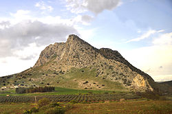
Peña de los Enamorados
| Peña de los Enamorados | |
|---|---|

Peña de los Enamorados seen from the railway line between Seville and Granada
|
|
| Coordinates | 37°4′4″N 4°29′24″W / 37.06778°N 4.49000°WCoordinates: 37°4′4″N 4°29′24″W / 37.06778°N 4.49000°W |
| Official name: Antequera Dolmens Site | |
| Type | Cultural |
| Criteria | i, iii, iv |
| Designated | 2016 (40th session) |
| Reference no. | 1501-002 |
| State Party | Spain |
| Region | Europe and North America |
| Peña de los Enamorados | |
|---|---|
| Highest point | |
| Elevation | 880 m (2,890 ft) |
| Coordinates | 37°4′4″N 4°29′24″W / 37.06778°N 4.49000°W |
| Geography | |
| Location | Málaga Province, Andalusia |
| Parent range | Penibaetic System |
| Geology | |
| Mountain type | Limestone |
| Climbing | |
| Easiest route | From Antequera |
Peña de los Enamorados ("The Lovers' Rock") is a mountain near the city of Antequera, Málaga Province, Andalusia, Spain. It reaches a height of 880 metres above sea level.
The mountain was named after a legend from the local oral tradition. The most well-known version of the legend says that two young Moorish lovers from rival clans, a young man from Antequera and girl from nearby Archidona, threw themselves from the rock while being pursued by the girl's father and his men. This romantic legend was later adapted by Robert Southey. In his Laila and Manuel the lovers were a Muslim girl and her father's Christian slave.
Christopher Columbus knew of this name. His chronicler, Barholome de Casas copied a log entry from Oct 29, 1492 in which Columus describes what he saw 8 days earlier in Cuba, "Remarking on the position of the river and port, to which he gave the name San Salvador, he described its mountains as lofty and beautiful, like the peña de las enamoradas... ". NB, the mistaken choice of gender by someone, be it the chronicler or the translator, the gender referenced is incorrect.
The mountain is also popularly known as "Montaña del Indio" because it looks like the head of an Indian when seen from certain angles.
...
Wikipedia

