Pawnee County, Oklahoma
| Pawnee County, Oklahoma | |
|---|---|

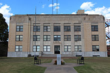
Pawnee County Courthouse, 2014
|
|
 Location in the U.S. state of Oklahoma |
|
 Oklahoma's location in the U.S. |
|
| Founded | 1893 |
| Named for | Pawnee Tribe |
| Seat | Pawnee |
| Largest city | Cleveland |
| Area | |
| • Total | 595 sq mi (1,541 km2) |
| • Land | 568 sq mi (1,471 km2) |
| • Water | 27 sq mi (70 km2), 4.5% |
| Population (est.) | |
| • (2013) | 16,513 |
| • Density | 29/sq mi (11/km²) |
| Congressional district | 3rd |
| Website | www |
Pawnee County is a county located in the U.S. state of Oklahoma. As of the 2010 census, the population was 16,577. Its county seat is Pawnee. The county is named after the Pawnee Tribe.
Pawnee County is included in the Tulsa, OK Metropolitan Statistical Area.
The Osage Tribe used the area that contains present day Pawnee County as buffalo hunting grounds. In 1825, The Osage ceded parts of present-day Missouri, Arkansas and most of the future state of Oklahoma to the federal government.
After their forced removal from the Southeastern United States, the Cherokee received land in Eastern Oklahoma as well as the Cherokee Outlet in 1828, which included present-day Pawnee County. After the Civil War, the Cherokee agreed to allow other American Indians to settle in the eastern portion of the Outlet. In 1873, the federal government began to relocate the Pawnee Tribe from Nebraska to a reservation here.
In 1891, the Pawnee agreed to take land allotments from the reservation, and the remaining land was opened to non-Indian settlers in 1893 during the Cherokee Outlet opening. Pawnee County was organized as County Q, and the future town of Pawnee, Townsite Number 13, was designated the county seat. In 1894, the voters chose the name Pawnee County over the name Platte County.
The female bandit, Little Britches, companion in crime with Cattle Annie, lived for a time at Sinnett, site of the Creek Nation in Pawnee County.
According to the U.S. Census Bureau, the county has a total area of 595 square miles (1,540 km2), of which 568 square miles (1,470 km2) is land and 27 square miles (70 km2) (4.5%) is water.
...
Wikipedia
