Paulatuk
|
Paulatuk Paulatuuq |
|
|---|---|
| Hamlet | |

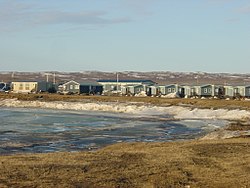
The hamlet of Paulatuk in May
|
|
| Coordinates: 69°21′05″N 124°04′10″W / 69.35139°N 124.06944°WCoordinates: 69°21′05″N 124°04′10″W / 69.35139°N 124.06944°W | |
| Country | Canada |
| Territory | Northwest Territories |
| Region | Inuvik Region |
| Constituency | Nunakput |
| Census division | Region 1 |
| Incorporated (hamlet) | 1 April 1987 |
| Government | |
| • Mayor | Ray Ruben Sr. |
| • Senior Administrative Officer | Greg Morash |
| • MLA | Jackie Jacobson |
| Area | |
| • Land | 66.86 km2 (25.81 sq mi) |
| Elevation | 5 m (16 ft) |
| Population (2011) | |
| • Total | 313 |
| • Density | 4.7/km2 (12/sq mi) |
| Time zone | Mountain (MST) (UTC-7) |
| • Summer (DST) | MDT (UTC-6) |
| Canadian Postal code | X0E 1N0 |
| Area code(s) | 867 |
| Telephone exchange | 580 |
| - Living cost | 177.5 |
| - Food price index | 195.9 |
| Sources: Department of Municipal and Community Affairs, Prince of Wales Northern Heritage Centre, Canada Flight Supplement ^A 2009 figure based on Edmonton = 100 ^B 2010 figure based on Yellowknife = 100 |
|
Paulatuk is a hamlet located in the Inuvik Region of the Northwest Territories, Canada. It is located adjacent to Darnley Bay, in the Amundsen Gulf. The town was named for the coal that was found in the area in the 1920s, and the Siglitun spelling is Paulatuuq, "place of coal".
The area has been inhabited by humans, including the Thule and Copper Inuit, since roughly 1000 AD. Most recently, it is part of the Inuvialuit Settlement Region. Paulatuk was incorporated as a hamlet in 1987 and celebrated the 50th anniversary of its settlement in 2015.
In 2014 the Government of the Northwest Territories reported that the population was 304 with an average yearly growth rate of -0.4 from 2001. At the 2011 census, Paulatuk had a population of 313, an increase of 6.5% over the 2006 Census. In the 2006 census 265 people were listed as Aboriginal and of these, 260 were Inuit (Inuvialuit). The two principal languages spoken in Paulatuk are Inuvialuktun and English.
The community is situated on Letty Harbour and was settled in the 1920s. This was followed a few years later by the Roman Catholic Church which opened a trading post. In the 1950s a Distant Early Warning Line site was built about 95 km (59 mi) to the northeast at Cape Parry, on the Parry Peninsula, providing a wage based income for the community. The trading post was taken over by the local co-op and today the local store is part of The North West Company.
...
Wikipedia

