Pauini
| Pauini | |
|---|---|
| Municipality | |
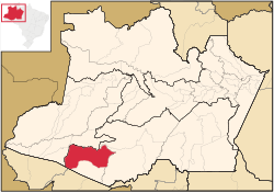
 Location of the municipality inside Amazonas |
|
| Coordinates: 7°42′50″S 66°58′33″W / 7.71389°S 66.97583°WCoordinates: 7°42′50″S 66°58′33″W / 7.71389°S 66.97583°W | |
| Country |
|
| Region | North |
| State |
|
| Time zone | BRT (UTC−4) |
| • Summer (DST) | DST no longer used (UTC−4) |
Pauini is a municipality located in the Brazilian state of Amazonas.
The population of Pauini was 17,125 in 2005. Its area is 43,263 square kilometres (16,704 sq mi). The municipality contains the 256,000 hectares (630,000 acres) Purus National Forest, created in 1988. It holds 8% of the 311,000 hectares (770,000 acres) Mapiá-Inauini National Forest, created in 1989. It also contains 8% of the 604,209 hectares (1,493,030 acres) Médio Purus Extractive Reserve, created in 2008.
...
Wikipedia
