
Patterson River
| Patterson | |
| Carrum Creek | |
| River | |
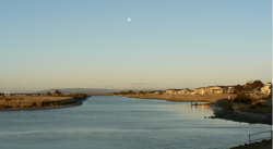 Patterson River, near Patterson Lakes
|
|
| Name origin: In honour of Sir James Patterson KCMG | |
| Country | Australia |
|---|---|
| State | Victoria |
| Regions | South East Coastal Plain (IBRA), Greater Melbourne |
| Local government area | City of Kingston |
| Part of | Port Phillip catchment |
| Landmark | National Water Sports Centre |
| Source confluence | Dandenong Creek and Eumemmerring Creek |
| - location | southwest of Bangholme |
| - elevation | 6 m (20 ft) |
| - coordinates | 38°2′37″S 145°10′29″E / 38.04361°S 145.17472°E |
| Mouth | Beaumaris Bay, Port Phillip |
| - location | at Carrum |
| - elevation | 0 m (0 ft) |
| - coordinates | 38°4′26″S 145°7′6″E / 38.07389°S 145.11833°ECoordinates: 38°4′26″S 145°7′6″E / 38.07389°S 145.11833°E |
| Length | 5 km (3 mi) |
The Patterson River is a partly man-made urban river of the Port Phillip catchment, located in the south-eastern Greater Melbourne region of the Australian state of Victoria. It is the shortest river in Victoria at only 5 kilometres in length.
Formed by the confluence of the Dandenong Creek and the Eumemmerring Creek, southwest of Bangholme approximately 35 kilometres (22 mi) south-east of Melbourne, the man-made Patterson River was constructed in 1878 to assist the drainage of swamplands located at what in now the suburb of Carrum. The urban channel flows generally southwest before emptying into Beaumaris Bay, an eastern bay within Port Phillip at the river mouth, near Carrum. The waterway provides access to canals in the suburbs of Patterson Lakes, Carrum and Bonbeach; and descends 5.4 metres (18 ft) over its 5-kilometre (3.1 mi) course.
As one of the few designated safe harbours on the city side of the bay, the Patterson River is the most popular boating gateway to Port Phillip Bay. The thriving canal system of the Patterson Lakes residential area and the wet and dry storage at the Patterson Lakes Marina combine with four public boat ramps to make an extremely busy waterway.
The river is traversed by the Nepean Highway at Carrum, and the Mornington Peninsula Freeway at Patterson Lakes.
In 1866 the Carrum Carrum Swamp was surveyed and the land between Mordialloc Creek and Keast Park in Seaford was divided into 18 allotments and sold by auction for around three pounds per acre. In 1871 the government opened it for selection. The swamp was an impediment to the settlers and there was much discussion on how to reclaim the land, the first contracts for drainage works commenced in 1873. Attempts to reclaim the lower swamplands were ineffective. In 1876 it was decided to cut a 10-metre (33 ft) wide channel to Port Phillip Bay through widening and deepening Carrum Creek. It was to be known as 'Patterson Cut' and had been named after Sir James Patterson KCMG, at the time the Victorian Minister for Public Works; and later Premier.
...
Wikipedia