Patterson, New South Wales
|
Paterson New South Wales |
|||||||||||||
|---|---|---|---|---|---|---|---|---|---|---|---|---|---|

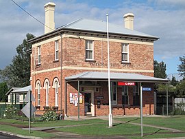
Paterson Post Office on the corner of Duke and King Streets
|
|||||||||||||
| Coordinates | 32°35′S 151°36′E / 32.583°S 151.600°ECoordinates: 32°35′S 151°36′E / 32.583°S 151.600°E | ||||||||||||
| Population | 345 (2006 census) | ||||||||||||
| Established | 1833 | ||||||||||||
| Postcode(s) | 2421 | ||||||||||||
| Elevation | 30 m (98 ft) | ||||||||||||
| Location | |||||||||||||
| LGA(s) | Dungog Shire | ||||||||||||
| County | Durham | ||||||||||||
| Parish | Houghton | ||||||||||||
| State electorate(s) | Upper Hunter | ||||||||||||
| Federal Division(s) | Paterson | ||||||||||||
|
|||||||||||||
|
|||||||||||||
Paterson is a small township in the lower Hunter Region of New South Wales, Australia. Located within Dungog Shire it is situated on the Paterson River. At the 2006 census, Paterson had a population of 345 people. It is in the middle of what was once dairy, timber and citrus country and is now more significantly a feeder town for the nearby mining industry in the Upper Hunter and the city of Newcastle.
It is approximately 15 minutes drive north along either Tocal or Paterson Roads from the nearest major township of Maitland. The Paterson railway station lies on the main North Coast Railway Line between Sydney and Brisbane with daily services north to Dungog and south-east to Newcastle.
Adjoining areas include Duns Creek, Martins Creek and Vacy.
The area was once occupied by the clan of the Wonnarua people, a group of indigenous people of Australia. The first known European in the area was the man whose name the town was to adopt, Colonel William Paterson, who, in 1801, surveyed the area beside the river that Governor King named in his honour.
As with so many colonial settlements, timbercutters, after local supplies of red cedar, followed in the footsteps of the explorers and surveyors. Indeed, the Paterson River was then known as the Cedar Arm due to the abundance of timber.
...
Wikipedia

