Parris Island, South Carolina
| Parris Island, South Carolina | |
|---|---|
| Former CDP | |
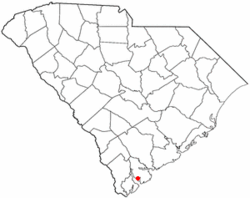
 Location of Parris Island, South Carolina |
|
| Coordinates: 32°19′44″N 80°41′41″W / 32.32889°N 80.69472°WCoordinates: 32°19′44″N 80°41′41″W / 32.32889°N 80.69472°W | |
| Country | United States |
| State | South Carolina |
| County | Beaufort |
| Area | |
| • Total | 19.6 sq mi (50.8 km2) |
| • Land | 12.2 sq mi (31.5 km2) |
| • Water | 7.4 sq mi (19.3 km2) |
| Population (2000) | |
| • Total | 4,841 |
| • Density | 398.0/sq mi (153.7/km2) |
| Time zone | Eastern (EST) (UTC-5) |
| • Summer (DST) | EDT (UTC-4) |
| ZIP codes | 29902, 29905 |
| Area code(s) | 843 |
| FIPS code | 45-54850 |
Parris Island is a former census-designated place (CDP), but was annexed in 2002 by Port Royal in Beaufort County, South Carolina, United States. The population was 4,841 at the 2000 census. As defined by the U.S. Census Bureau, Parris Island is included within the Beaufort Urban Cluster and the larger Hilton Head Island–Beaufort Micropolitan Statistical Area. The area was annexed by the town of Port Royal on October 11, 2002.
It is perhaps best known for its U.S. Marine Corps training facility Marine Corps Recruit Depot Parris Island, where about 16,000 Marines pass through boot camp every year.
Parris Island was first colonized by Europeans in 1562, when members of a French expedition led by Jean Ribaut temporarily settled on the island. This was the first semi-permanent European settlement in what are considered now the United States. Four years later, a town named Santa Elena was founded here by Spanish Conquistador Pedro Menéndez de Avilés after troops sent by the Spanish monarch slaughtered French colonists and their Amerindian allies in 1565. It was the capital of La Florida from 1566 to 1587, during which time Spanish explorers sailed from Santa Elena to explore the Tennessee valley and Chesapeake Bay. An expedition also traveled overland into the interior to western North Carolina and points west.
...
Wikipedia
