Parpan
| Parpan | ||
|---|---|---|
| Former municipality of Switzerland | ||
 |
||
|
||
| Coordinates: 46°47′N 9°33′E / 46.783°N 9.550°ECoordinates: 46°47′N 9°33′E / 46.783°N 9.550°E | ||
| Country | Switzerland | |
| Canton | Graubünden | |
| District | Plessur | |
| Area | ||
| • Total | 9.30 km2 (3.59 sq mi) | |
| Elevation | 1,493 m (4,898 ft) | |
| Population | ||
| • Total | 245 | |
| • Density | 26/km2 (68/sq mi) | |
| Postal code | 7076 | |
| SFOS number | 3913 | |
| Surrounded by | Churwalden, Tschiertschen, Vaz/Obervaz | |
| Website |
www SFSO statistics |
|
Parpan was a municipality in the district Plessur of the canton of Graubünden in Switzerland. On 1 January 2010 the municipalities of Malix and Parpan merged into Churwalden.
Parpan is first mentioned in 1208 as Partipan. Formerly in Romansh it was known as Parpaun.
Parpan is a common surname in Graubünden. Etymologically "Parpan" originates from the French partis-pain, meaning "bread-deliverer".
Parpan has an area, as of 2006[update], of 9.3 km2 (3.6 sq mi). Of this area, 64.9% is used for agricultural purposes, while 22.8% is forested. Of the rest of the land, 3.1% is settled (buildings or roads) and the remainder (9.1%) is non-productive (rivers, glaciers or mountains).
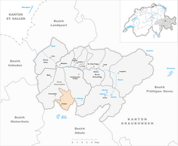
The municipality is located in the Churwalden sub-district of the Plessur district in the Churwalden valley. The village lies in the valley between the cantonal capital Chur and the resort Lenzerheide. It offers access to the skiing area of Rothorn and mountain railways Danis Staetz AG. The finish of the Alpine skiing World Cup slope "Silvano Beltrametti" for the downhill race in Lenzerheide is in Parpan.
At the end of 2013 the ski resort was linked with Arosa by cable-car, creating the new ski resort of Arosa Lenzerheide. Since then transport passes work in both resorts.
Parpan municipality consists of the Haufendorf village (an irregular, unplanned and quite closely packed village, built around a central square) of Parpan. The municipalities of Malix and Parpan merged on 1 January 2010 into the municipality of Churwalden.
...
Wikipedia


