Paradise, Nevada
| Paradise, Nevada | |
|---|---|
| Unincorporated town | |

The Las Vegas Strip, largely located within Paradise
|
|
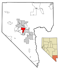
 Location of Paradise in Clark County, Nevada |
|
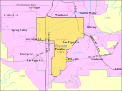
 U.S. Census Map |
|
| Location in the United States | |
| Coordinates: 36°4′55″N 115°7′29″W / 36.08194°N 115.12472°W | |
| Country | United States |
| State | Nevada |
| County | Clark |
| Area | |
| • Total | 46.7 sq mi (121 km2) |
| • Land | 46.7 sq mi (121 km2) |
| • Water | 0.0 sq mi (0 km2) |
| Elevation | 2,057 ft (627 m) |
| Population (2010) | |
| • Total | 223,167 |
| • Density | 4,777/sq mi (1,844/km2) |
| Time zone | PST (UTC-8) |
| • Summer (DST) | PDT (UTC-7) |
| Area code(s) | 702 |
| FIPS code | 32-54600 |
| GNIS feature ID | 0845094 |
| Website | Paradise Town Advisory Board |
Coordinates: 36°4′55″N 115°7′29″W / 36.08194°N 115.12472°W
Paradise is an unincorporated town and census-designated place (CDP) in Clark County, Nevada, United States, adjacent to the city of Las Vegas. The population was 223,167 at the 2010 census, making it the most populous unincorporated community in Nevada and more populous than any city in the state outside Clark County. As an unincorporated town, it is governed by the Clark County Commission with input from the Paradise Town Advisory Board. Paradise was formed on December 8, 1950.
Paradise contains McCarran International Airport; the University of Nevada, Las Vegas; and most of the Las Vegas Strip. Paradise contains most tourist attractions in the Las Vegas area, excluding downtown. Despite this, the name Paradise remains relatively unknown. All Paradise ZIP codes have Las Vegas mailing addresses.
The southern part of the Las Vegas Valley was referred to as Paradise Valley as early as 1910, owing to a high water table that made the land particularly fertile for farming. County commissioners established a Paradise school district in 1914.
...
Wikipedia

