Panna District
|
Panna district पन्ना जिला |
|
|---|---|
| District of Madhya Pradesh | |
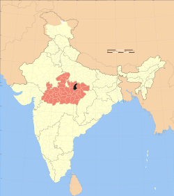
 Location of Panna district in Madhya Pradesh |
|
| Country | India |
| State | Madhya Pradesh |
| Administrative division | Sagar |
| Headquarters | Panna, India |
| Tehsils | Panna |
| Government | |
| • Lok Sabha constituencies | Khajuraho |
| Area | |
| • Total | 7,135 km2 (2,755 sq mi) |
| Population (2011) | |
| • Total | 10,16,028 |
| • Density | 140/km2 (370/sq mi) |
| Demographics | |
| • Literacy | 66.08 % |
| • Sex ratio | 907 |
| Major highways | NH 75 |
| Website | Official website |
Panna district is a district of the Sagar Division, within the Madhya Pradesh state in central India. The town of Panna is the district headquarters.
Panna district was created in 1950, shortly after Indian independence, from the territory of several former princely states of British India, including the states of Panna, Jaso, most of Ajaigarh, and a portion of Paldeo. Panna District was part of the new Indian state of Vindhya Pradesh, which was merged into Madhya Pradesh on 1 November 1956.
Panna district lies between 23° 45' and 25° 10' north latitudes and 79° 45' and 80° 40' east longitudes. It has an area of 7,135 km2.
The Ken River flows through the district. The Pandav Falls and the Gatha Falls are located in the district. Panna National Park is a major tourist attraction in the district.
In 2006 the Ministry of Panchayati Raj named Panna one of the country's 250 most backward districts (out of a total of 640). It is one of the 24 districts in Madhya Pradesh currently receiving funds from the Backward Regions Grant Fund Programme (BRGF).
...
Wikipedia
