Panglao, Bohol
| Panglao | |
|---|---|
| Municipality | |

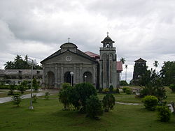
St. Augustine church and watchtower
|
|
 Map of Bohol with Panglao highlighted |
|
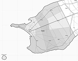
 Map of Panglao showing barangays and islands |
|
| Location within the Philippines | |
| Coordinates: 9°35′N 123°45′E / 9.58°N 123.75°ECoordinates: 9°35′N 123°45′E / 9.58°N 123.75°E | |
| Country | Philippines |
| Region | Central Visayas (Region VII) |
| Province | Bohol |
| District | 1st district of Bohol |
| Founded | 1803 |
| Barangay |
10 (see § Barangays)
|
| Government | |
| • Type | Sangguniang Bayan |
| • Mayor | Leonila Montero (PDP) |
| • Vice mayor | Pedro Fuertes |
| • Town Council |
Members
|
| • Representative | Rene Relampagos |
| Area | |
| • Total | 51.20 km2 (19.77 sq mi) |
| incl. Balicasag island and others | |
| Population (2015 census) | |
| • Total | 33,553 |
| • Density | 660/km2 (1,700/sq mi) |
| • Voter (2016) | 21,394 |
| Time zone | PST (UTC+8) |
| ZIP code | 6340 |
| IDD : area code | +63 (0)38 |
| Income class | 4th class |
| PSGC | 071233000 |
| Website | www |
Panglao is a 4th municipal income class municipality in the province of Bohol, Philippines. According to the 2015 census, it has a population of 33,553, 18 kilometres (11 mi) from Tagbilaran. In the 2016 electoral roll, it had 21,394 registered voters.
It is one of two municipalities that make up Panglao Island (the other being Dauis), and its territory also includes the three smaller islands of Balicasag, Gak‑ang, and Pontod (or Pungtud, also known as Virgin Island). Panglao is known for its diving locations and tourist resorts.
The name Panglao may have come from its former name Panglawod, meaning "to the open sea", or derived from the word panggaw, referring to a fishing implement used by locals.
Panglao has educational institutions, including the San Agustin Academy (Panglao), Lourdes National High School, the Cristal e-College, and elementary schools located in every barangay (including the Panglao Central Elementary School).
There are no fresh water streams or lakes on the island, so for its drinking water, the municipality is dependent on wells and the Canhilbas Underground Spring.
Well before the Spanish colonization, the area was already long visited by Chinese and other Asian traders, as evinced by archaeological finds of Tang, Song, and Ming dynasty porcelain and trade wares.
Panglao flourished during the rule of the Dapitan kingdom, but raids by Moluccans and conquest by Ternate resulted in periods of depopulation when its population fled mostly to Panay and Mindanao, including Dapitan.
During the Spanish rule, a Jesuit mission post was established, that in 1782 was formed into a parish, known as La Iglesia de San Agustin de Panglawod. In 1803, the town was officially made into a municipality.
...
Wikipedia

