Pandi, Bulacan
| Pandi | ||
|---|---|---|
| Municipality | ||

Immaculate Conception Parish Church
|
||
|
||
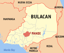
 Map of Bulacan showing the location of Pandi |
||
| Location within the Philippines | ||
| Coordinates: 14°52′N 120°57′E / 14.87°N 120.95°ECoordinates: 14°52′N 120°57′E / 14.87°N 120.95°E | ||
| Country | Philippines | |
| Region | Central Luzon (Region III) | |
| Province | Bulacan | |
| District | 2nd District | |
| Founded | April 17, 1946 | |
| Barangays | 22 | |
| Government | ||
| • Mayor | Celestino T. Marquez (KBL) | |
| • Vice Mayor | Atty. Noel Roxas (KBL) | |
| Area | ||
| • Total | 31.20 km2 (12.05 sq mi) | |
| Population (2015 census) | ||
| • Total | 89,075 | |
| • Density | 2,900/km2 (7,400/sq mi) | |
| • Poverty rate |
|
|
| Time zone | PST (UTC+8) | |
| ZIP code | 3014 | |
| IDD : area code | +63 (0)44 | |
| Income class | 2nd class; urban | |
| Electricity | Manila Electric Company | |
| • Consumption | 23.31 million kWh (2003) | |
Pandi is a second class urban municipality in the province of Bulacan, Philippines. The municipality of Pandi lies 41 kilometres (25 mi) north-east of Manila and is located at the eastern portion of Bulacan Province. According to the 2015 census, it has a population of 89,075 people.
With the continuous expansion of Metro Manila, Pandi is now included in the Greater Manila's built-up area which reaches San Ildefonso, Bulacan at its northernmost part.
Pandi is one of the youngest towns in Bulacan. During the Spanish Regime, Pandi was a part of the political jurisdiction of the town of Meycauayan City including the towns of San Jose del Monte, Bocaue, Marilao, Valenzuela, Obando, Santa Maria, Balagtas, it also formed part of the vast Hacienda Santa Maria de Pandi, which included the towns of Sta. Maria and Balagtas and parts of Angat and Bustos. Pandi was then a part of the town Balagtas (then Bigaa until its formal separation and independence on April 17, 1946.
...
Wikipedia


