Pampus

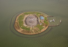
Pampus island in 2013
|
|
| Geography | |
|---|---|
| Location | IJmeer |
| Area | 0.03 km2 (0.012 sq mi) |
| Length | 205 m (673 ft) |
| Width | 164 m (538 ft) |
| Administration | |
| Province | North Holland |
| Municipality | Gooise Meren |
| Demographics | |
| Population | 2 |
| Pop. density | 67 /km2 (174 /sq mi) |
Coordinates: 52°21′53″N 5°4′8″E / 52.36472°N 5.06889°E
Pampus (Dutch pronunciation: [ˈpɑmpɵs]) is an artificial island and late 19th-century sea fort located in the IJmeer near Amsterdam. It now belongs to the municipality of Gooise Meren and is open to visitors.
Together with the artillery battery on the lighthouse island near Durgerdam and the battery at the Diemer seawall, Pampus protected the entrance to IJ Bay and the harbour of Amsterdam. It was part of the Defence Line of Amsterdam (Dutch: Stelling van Amsterdam). In 1996, UNESCO designated the entire Defence Line with its 42 forts a World Heritage Site.
The fort is on a man-made island situated on what was the Pampus shallows or sandbank in the then Zuiderzee. There is a well-known Dutch expression "laying for Pampus" used to describe people that are lying down knocked out. It stems from the time ships had to wait for high tide at Pampus before they could enter the harbour of Amsterdam.
...
Wikipedia

