Palmer Goldfield
| Palmer | |
| River | |
|
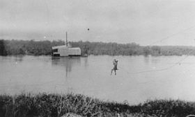
A gold mining dredge on the Palmer River.
|
|
| Name origin: In honour of Sir Arthur Hunter Palmer | |
| Country | Australia |
|---|---|
| State | Queensland |
| Region | Far North Queensland |
| Part of | Mitchell River catchment |
| Tributaries | |
| - left | South Palmer River |
| - right | Little Palmer River, North Palmer River |
| Source | Sussex Range, Great Dividing Range |
| Source confluence | Prospect Creek and Campbell Creek |
| - location | near Palmer River Roadhouse |
| - elevation | 429 m (1,407 ft) |
| - coordinates | 16°06′18″S 144°46′52″E / 16.10500°S 144.78111°E |
| Mouth | confluence with the Mitchell River |
| - location | northeast of Staaten River National Park |
| - elevation | 64 m (210 ft) |
| - coordinates | 16°04′52″S 142°42′49″E / 16.08111°S 142.71361°ECoordinates: 16°04′52″S 142°42′49″E / 16.08111°S 142.71361°E |
| Length | 327 km (203 mi) |
| Basin | 8,335 km2 (3,218 sq mi) |
|
Location of Palmer River mouth in Queensland
|
|
The Palmer River is a river located in Far North Queensland, Australia. The area surrounding the river was the site of a gold rush in the late 19th century which started in 1873.
The headwaters of the Palmer River rise in the Sussex Range, part of the Great Dividing Range southwest of Cooktown. The river is formed by the confluence of the Prospect Creek and Campbell Creek, near Palmer River Roadhouse, south of Lakeland. The Palmer River flows west across the Cape York Peninsula towards the Gulf of Carpentaria joined by 29 tributaries including the South Palmer River, Little Palmer River and North Palmer River, before reaching its confluence with the Mitchell River northeast of Staaten River National Park. The river descends 365 metres (1,198 ft) over its 327-kilometre (203 mi) course and has a catchment area of 8,335 square kilometres (3,218 sq mi).
Palmer River was one of Australia's major gold rush locations. William Hann and geologist Norman Taylor found gold in a sandy bed of the river in 1872. Hann named the river after Arthur Hunter Palmer the Premier of Queensland at that time.
The main settlement of the gold field was Maytown replacing Palmerville after some months. The settlement began as a camp in 1873, then grew into a town which served as the administration centre for the former Hann Local Government Area. The settlements of Byerstown and Idatown were also established along the river.
...
Wikipedia


