Palm Springs International Airport
| Palm Springs International Airport Palm Springs Army Airfield |
|||||||||||||||
|---|---|---|---|---|---|---|---|---|---|---|---|---|---|---|---|
 |
|||||||||||||||
| Summary | |||||||||||||||
| Airport type | Public | ||||||||||||||
| Owner | City of Palm Springs | ||||||||||||||
| Operator | Palm Springs Aviation Department | ||||||||||||||
| Serves | Inland Empire | ||||||||||||||
| Location | Palm Springs, California | ||||||||||||||
| Elevation AMSL | 476 ft / 145 m | ||||||||||||||
| Coordinates | 33°49′47″N 116°30′24″W / 33.82972°N 116.50667°W | ||||||||||||||
| Website | Palm Springs International Airport | ||||||||||||||
| Maps | |||||||||||||||
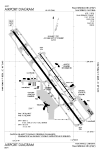
 FAA airport diagram |
|||||||||||||||
| Location within California/United States | |||||||||||||||
| Runways | |||||||||||||||
|
|||||||||||||||
| Statistics (2016) | |||||||||||||||
|
|||||||||||||||
|
Source=FAA
|
|||||||||||||||
| Passengers | 1,998,206 |
|---|---|
| Aircraft operations | 55,924 |
Palm Springs International Airport (IATA: PSP, ICAO: KPSP, FAA LID: PSP), formerly Palm Springs Municipal Airport, is a public airport two miles (3 km) east of downtown Palm Springs, California. The airport covers 940 acres (380 ha) and has two runways. The airport is highly seasonal, with most flights operating during the winter.
The airport was named one of "America's Most Stress-Free Airports" by Smarter Travel.
PSP was built as a United States Army Air Corps emergency landing field in 1939 on land owned by the Agua Caliente Band of Cahuilla Indians due to its clear weather and its proximity to March Field and the Los Angeles area.
In March 1941 the War Department certified improvements to the existing airport in Palm Springs as essential to National Defense. The airport was approved to serve as a staging field by the Air Corps Ferrying Command 21st Ferrying Group in November 1941. Land was acquired to build a major airfield one half miles from the old airfield site. The new airfield, Palm Springs Army Airfield was completed in early 1942, and the old air field was then used only as a backup. (Aerial pic of the old airfield at 33°49′37″N 116°31′59″W / 33.827°N 116.533°W, looking ENE)
...
Wikipedia


