Palm Bay – Melbourne – Titusville, Florida Metropolitan Statistical Area
| Brevard County, Florida | |||||
|---|---|---|---|---|---|
| County | |||||
| Brevard County | |||||

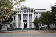
Historic Brevard County Courthouse in Titusville.
|
|||||
|
|||||
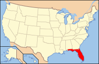
 Location in the U.S. state of Florida |
|||||
 Florida's location in the U.S. |
|||||
| Founded | 14 March, 1844 | ||||
| Named for | Theodorus W. Brevard | ||||
| Seat | Titusville | ||||
| Largest city | Palm Bay | ||||
| Area | |||||
| • Total | 1,557 sq mi (4,033 km2) | ||||
| • Land | 1,016 sq mi (2,631 km2) | ||||
| • Water | 541 sq mi (1,401 km2), 34.8% | ||||
| Population (est.) | |||||
| • (2015) | 568,088 | ||||
| • Density | 535/sq mi (207/km²) | ||||
| Congressional district | 8th | ||||
| Time zone | Eastern: UTC-5/-4 | ||||
| Website | www |
||||
Brevard County is a county in the state of Florida. As of the 2010 census, the population was 543,376, making it the 10th largest county in Florida. The official county seat has been located in Titusville since 1894. Brevard County comprises the Palm Bay–Melbourne–Titusville, FL Metropolitan Statistical Area. It is located along the east Florida coast along the Atlantic Ocean.
Influenced by the presence of the John F. Kennedy Space Center, Brevard County is also known as the Space Coast. As such, it was designated with the telephone area code 321, as in 3-2-1 liftoff. The county is named after Theodore Washington Brevard, an early Florida settler, and state comptroller.
The history of Brevard County can be traced to the prehistory of native cultures living in the area from pre-Columbian times to the present age. The geographic boundaries of the county have changed significantly since its founding. The county is named for Judge Theodore W. Brevard, an early setter, and state comptroller.
In federal maps printed before 2012, nearly half of Brevard was prone to flooding. Most of this was in the relatively undeveloped low-lying areas, west of Interstate 95, on the banks of the St. Johns River. About 18,900 homes out of 164,000 single-family homes were in that area.
According to the U.S. Census Bureau, the county has a total area of 1,557 square miles (4,030 km2), of which 1,016 square miles (2,630 km2) is land and 541 square miles (1,400 km2) (34.8%) is water. Most of the water is the Atlantic Ocean, the St. Johns River and the Indian River Lagoon. The county is larger in area than the nation of Samoa and nearly the same size, and population, as Cape Verde. It is one-third the size of the state of Rhode Island.
...
Wikipedia


