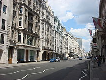
Pall Mall East
 |
|
|---|---|

Pall Mall in 2009
|
|
| Length | 0.4 mi (0.6 km) |
| Location | Westminster, London, United Kingdom |
| Postal code | SW1 |
| Nearest train station |
|
| Coordinates | 51°30′25″N 0°07′59″W / 51.506944°N 0.133056°WCoordinates: 51°30′25″N 0°07′59″W / 51.506944°N 0.133056°W |
| East end | Haymarket |
| West end | St James's Street |
| Construction | |
| Commissioned | July 1661 |
| Inauguration | September 1661 |
| Other | |
| Known for | |
Pall Mall /ˌpæl ˈmæl/ is a street in the St James's area of the City of Westminster, Central London. It connects St James's Street to Trafalgar Square and is a section of the regional A4 road. The street's name is derived from "pall-mall", a ball game played there during the 17th century.
The area was built up during the reign of Charles II with fashionable London residences. It became known for high-class shopping in the 18th century, and gentlemen's clubs in the 19th. The Reform, Athenaeum and Travellers Clubs have survived to the 21st century. The War Office was based on Pall Mall during the second half of the 19th century, and the Royal Automobile Club's headquarters have been on the street since 1908.
The street is around 0.4 miles (0.64 km) long and runs east in the St James's area, from St James's Street across Waterloo Place, to the Haymarket and continues as Pall Mall East towards Trafalgar Square. The street numbers run consecutively from north-side east to west and then continue on the south-side west to east. It is part of the A4, a major road running west from Central London.London Bus Route 9 runs westwards along Pall Mall, connecting Trafalgar Square to Piccadilly and Hyde Park Corner.
...
Wikipedia

